You are here: Home > Network List > TA - USArray Transportable Network (new EarthScope stations) Stations List
> Station SFIN Lafayette, IN, USA > Earthquake Result Viewer
SFIN Lafayette, IN, USA - Earthquake Result Viewer
| Earthquake location: |
Near Coast Of Northern Chile |
| Earthquake latitude/longitude: |
-20.5/-70.5 |
| Earthquake time(UTC): |
2014/04/03 (093) 02:43:14 GMT |
| Earthquake Depth: |
31 km |
| Earthquake Magnitude: |
7.7 MWW, 7.4 MI, 7.7 MWC |
| Earthquake Catalog/Contributor: |
NEIC PDE/NEIC COMCAT |
|
| Network: |
TA USArray Transportable Network (new EarthScope stations) |
| Station: |
SFIN Lafayette, IN, USA |
| Lat/Lon: |
40.38 N/87.10 W |
| Elevation: |
165 m |
|
| Distance: |
62.5 deg |
| Az: |
345.761 deg |
| Baz: |
162.434 deg |
| Ray Param: |
0.060118318 |
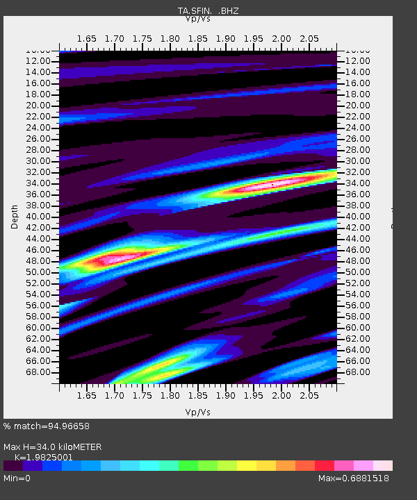
| Estimated Moho Depth: |
34.0 km |
| Estimated Crust Vp/Vs: |
1.98 |
| Assumed Crust Vp: |
6.498 km/s |
| Estimated Crust Vs: |
3.277 km/s |
| Estimated Crust Poisson's Ratio: |
0.33 |
|
| Radial Match: |
94.96658 % |
| Radial Bump: |
270 |
| Transverse Match: |
79.7887 % |
| Transverse Bump: |
400 |
| SOD ConfigId: |
626651 |
| Insert Time: |
2014-04-22 04:57:06.116 +0000 |
| GWidth: |
2.5 |
| Max Bumps: |
400 |
| Tol: |
0.001 |
|
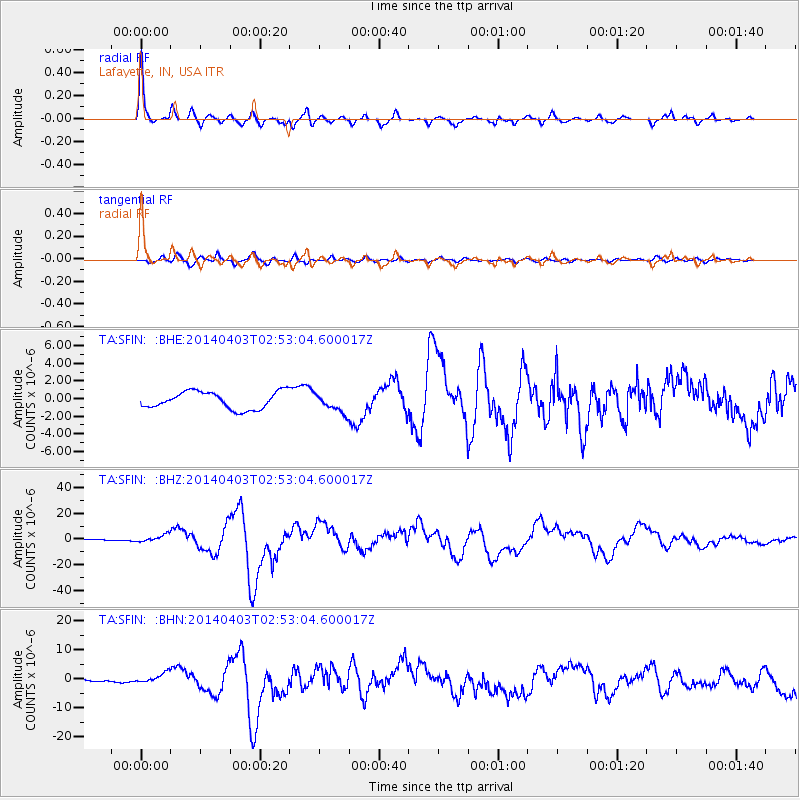
Signal To Noise
| Channel | StoN | STA | LTA |
| TA:SFIN: :BHZ:20140403T02:53:04.600017Z | 4.6039844 | 2.879147E-6 | 6.2535986E-7 |
| TA:SFIN: :BHN:20140403T02:53:04.600017Z | 4.7907753 | 1.8298986E-6 | 3.8196293E-7 |
| TA:SFIN: :BHE:20140403T02:53:04.600017Z | 1.0887825 | 1.0518181E-6 | 9.660497E-7 |
| Arrivals |
| Ps | 5.4 SECOND |
| PpPs | 15 SECOND |
| PsPs/PpSs | 20 SECOND |


