You are here: Home > Network List > TA - USArray Transportable Network (new EarthScope stations) Stations List
> Station T49A Edmonton, KY, USA > Earthquake Result Viewer
T49A Edmonton, KY, USA - Earthquake Result Viewer
| Earthquake location: |
Near Coast Of Northern Chile |
| Earthquake latitude/longitude: |
-20.5/-70.5 |
| Earthquake time(UTC): |
2014/04/03 (093) 02:43:14 GMT |
| Earthquake Depth: |
31 km |
| Earthquake Magnitude: |
7.7 MWW, 7.4 MI, 7.7 MWC |
| Earthquake Catalog/Contributor: |
NEIC PDE/NEIC COMCAT |
|
| Network: |
TA USArray Transportable Network (new EarthScope stations) |
| Station: |
T49A Edmonton, KY, USA |
| Lat/Lon: |
37.10 N/85.53 W |
| Elevation: |
313 m |
|
| Distance: |
59.0 deg |
| Az: |
346.004 deg |
| Baz: |
163.528 deg |
| Ray Param: |
0.06239769 |
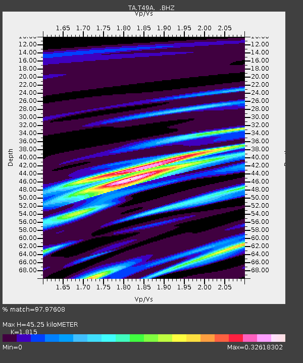
| Estimated Moho Depth: |
45.25 km |
| Estimated Crust Vp/Vs: |
1.82 |
| Assumed Crust Vp: |
6.476 km/s |
| Estimated Crust Vs: |
3.568 km/s |
| Estimated Crust Poisson's Ratio: |
0.28 |
|
| Radial Match: |
97.97608 % |
| Radial Bump: |
203 |
| Transverse Match: |
90.173775 % |
| Transverse Bump: |
400 |
| SOD ConfigId: |
626651 |
| Insert Time: |
2014-04-22 04:57:25.018 +0000 |
| GWidth: |
2.5 |
| Max Bumps: |
400 |
| Tol: |
0.001 |
|

Signal To Noise
| Channel | StoN | STA | LTA |
| TA:T49A: :BHZ:20140403T02:52:40.949993Z | 5.215842 | 2.5479976E-6 | 4.885113E-7 |
| TA:T49A: :BHN:20140403T02:52:40.949993Z | 2.3828485 | 9.428317E-7 | 3.9567422E-7 |
| TA:T49A: :BHE:20140403T02:52:40.949993Z | 1.2770548 | 4.805053E-7 | 3.7626054E-7 |
| Arrivals |
| Ps | 6.0 SECOND |
| PpPs | 19 SECOND |
| PsPs/PpSs | 25 SECOND |


