You are here: Home > Network List > TA - USArray Transportable Network (new EarthScope stations) Stations List
> Station T53A Wise, VA, USA > Earthquake Result Viewer
T53A Wise, VA, USA - Earthquake Result Viewer
| Earthquake location: |
Near Coast Of Northern Chile |
| Earthquake latitude/longitude: |
-20.5/-70.5 |
| Earthquake time(UTC): |
2014/04/03 (093) 02:43:14 GMT |
| Earthquake Depth: |
31 km |
| Earthquake Magnitude: |
7.7 MWW, 7.4 MI, 7.7 MWC |
| Earthquake Catalog/Contributor: |
NEIC PDE/NEIC COMCAT |
|
| Network: |
TA USArray Transportable Network (new EarthScope stations) |
| Station: |
T53A Wise, VA, USA |
| Lat/Lon: |
36.98 N/82.54 W |
| Elevation: |
818 m |
|
| Distance: |
58.3 deg |
| Az: |
348.682 deg |
| Baz: |
166.719 deg |
| Ray Param: |
0.06287698 |
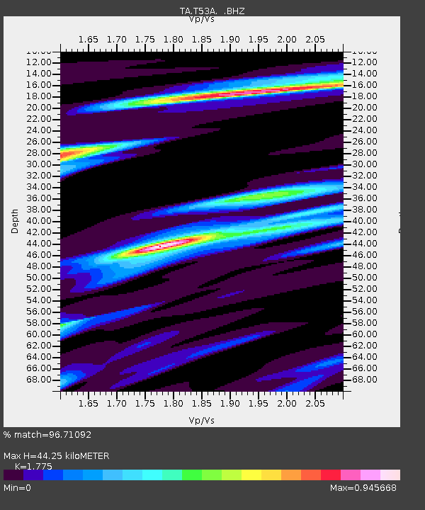
| Estimated Moho Depth: |
44.25 km |
| Estimated Crust Vp/Vs: |
1.77 |
| Assumed Crust Vp: |
6.476 km/s |
| Estimated Crust Vs: |
3.648 km/s |
| Estimated Crust Poisson's Ratio: |
0.27 |
|
| Radial Match: |
96.71092 % |
| Radial Bump: |
333 |
| Transverse Match: |
88.44421 % |
| Transverse Bump: |
400 |
| SOD ConfigId: |
626651 |
| Insert Time: |
2014-04-22 04:57:34.031 +0000 |
| GWidth: |
2.5 |
| Max Bumps: |
400 |
| Tol: |
0.001 |
|

Signal To Noise
| Channel | StoN | STA | LTA |
| TA:T53A: :BHZ:20140403T02:52:35.850017Z | 3.6848695 | 1.3831371E-6 | 3.753558E-7 |
| TA:T53A: :BHN:20140403T02:52:35.850017Z | 4.1398187 | 7.4950003E-7 | 1.810466E-7 |
| TA:T53A: :BHE:20140403T02:52:35.850017Z | 1.7779968 | 3.851725E-7 | 2.1663286E-7 |
| Arrivals |
| Ps | 5.6 SECOND |
| PpPs | 18 SECOND |
| PsPs/PpSs | 24 SECOND |


