You are here: Home > Network List > TA - USArray Transportable Network (new EarthScope stations) Stations List
> Station 121A Cookes Peak, Deming, NM, USA > Earthquake Result Viewer
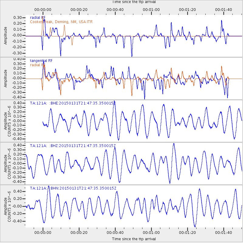
121A Cookes Peak, Deming, NM, USA - Earthquake Result Viewer
*The percent match for this event was below the threshold and hence no stack was calculated.
| Earthquake location: |
Kermadec Islands Region |
| Earthquake latitude/longitude: |
-31.5/-177.8 |
| Earthquake time(UTC): |
2015/01/31 (031) 21:35:02 GMT |
| Earthquake Depth: |
35 km |
| Earthquake Magnitude: |
4.9 mb, 5.0 mb, 4.1 MS |
| Earthquake Catalog/Contributor: |
ISC/ISC |
|
| Network: |
TA USArray Transportable Network (new EarthScope stations) |
| Station: |
121A Cookes Peak, Deming, NM, USA |
| Lat/Lon: |
32.53 N/107.79 W |
| Elevation: |
1652 m |
|
| Distance: |
91.8 deg |
| Az: |
52.589 deg |
| Baz: |
233.411 deg |
| Ray Param: |
$rayparam |
*The percent match for this event was below the threshold and hence was not used in the summary stack. |
|
| Radial Match: |
49.491238 % |
| Radial Bump: |
400 |
| Transverse Match: |
51.57974 % |
| Transverse Bump: |
400 |
| SOD ConfigId: |
6962031 |
| Insert Time: |
2019-04-16 08:19:02.424 +0000 |
| GWidth: |
2.5 |
| Max Bumps: |
400 |
| Tol: |
0.001 |
|
Signal To Noise
| Channel | StoN | STA | LTA |
| TA:121A: :BHZ:20150131T21:47:35.350015Z | 0.9074142 | 1.5838195E-7 | 1.7454207E-7 |
| TA:121A: :BHN:20150131T21:47:35.350015Z | 2.5606651 | 3.315071E-7 | 1.2946133E-7 |
| TA:121A: :BHE:20150131T21:47:35.350015Z | 0.9231033 | 1.18797736E-7 | 1.2869387E-7 |
| Arrivals |
| Ps | |
| PpPs | |
| PsPs/PpSs | |


