You are here: Home > Network List > TA - USArray Transportable Network (new EarthScope stations) Stations List
> Station U60A Pendleton, NC, USA > Earthquake Result Viewer
U60A Pendleton, NC, USA - Earthquake Result Viewer
| Earthquake location: |
Near Coast Of Northern Chile |
| Earthquake latitude/longitude: |
-20.5/-70.5 |
| Earthquake time(UTC): |
2014/04/03 (093) 02:43:14 GMT |
| Earthquake Depth: |
31 km |
| Earthquake Magnitude: |
7.7 MWW, 7.4 MI, 7.7 MWC |
| Earthquake Catalog/Contributor: |
NEIC PDE/NEIC COMCAT |
|
| Network: |
TA USArray Transportable Network (new EarthScope stations) |
| Station: |
U60A Pendleton, NC, USA |
| Lat/Lon: |
36.47 N/77.16 W |
| Elevation: |
8.0 m |
|
| Distance: |
57.0 deg |
| Az: |
353.601 deg |
| Baz: |
172.553 deg |
| Ray Param: |
0.06370054 |
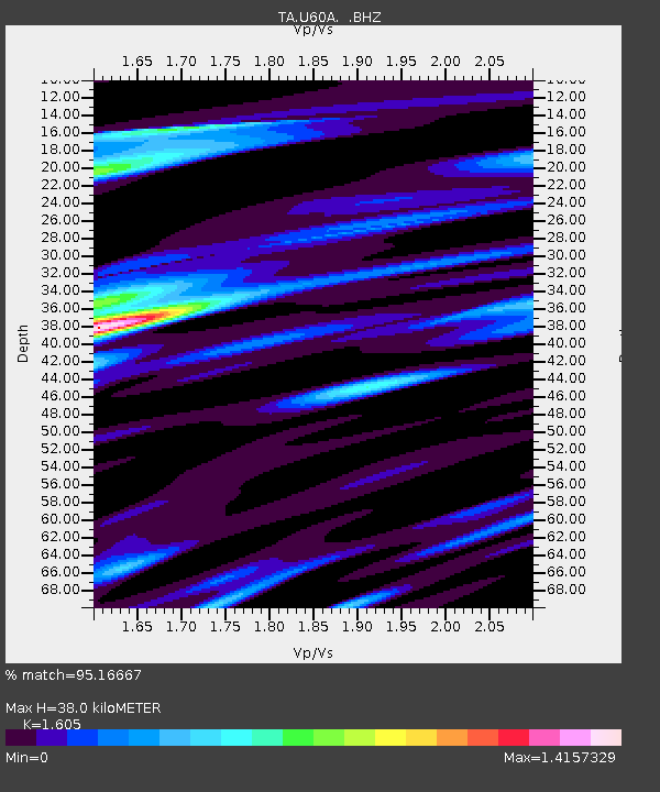
| Estimated Moho Depth: |
38.0 km |
| Estimated Crust Vp/Vs: |
1.61 |
| Assumed Crust Vp: |
6.565 km/s |
| Estimated Crust Vs: |
4.09 km/s |
| Estimated Crust Poisson's Ratio: |
0.18 |
|
| Radial Match: |
95.16667 % |
| Radial Bump: |
400 |
| Transverse Match: |
90.65215 % |
| Transverse Bump: |
400 |
| SOD ConfigId: |
626651 |
| Insert Time: |
2014-04-22 04:58:27.651 +0000 |
| GWidth: |
2.5 |
| Max Bumps: |
400 |
| Tol: |
0.001 |
|

Signal To Noise
| Channel | StoN | STA | LTA |
| TA:U60A: :BHZ:20140403T02:52:26.900005Z | 3.518492 | 1.6691906E-6 | 4.7440514E-7 |
| TA:U60A: :BHN:20140403T02:52:26.900005Z | 2.877677 | 9.534966E-7 | 3.313425E-7 |
| TA:U60A: :BHE:20140403T02:52:26.900005Z | 2.6686954 | 8.952394E-7 | 3.3545956E-7 |
| Arrivals |
| Ps | 3.7 SECOND |
| PpPs | 14 SECOND |
| PsPs/PpSs | 18 SECOND |


