You are here: Home > Network List > TA - USArray Transportable Network (new EarthScope stations) Stations List
> Station W60A Pink Hill, NC, USA > Earthquake Result Viewer
W60A Pink Hill, NC, USA - Earthquake Result Viewer
| Earthquake location: |
Near Coast Of Northern Chile |
| Earthquake latitude/longitude: |
-20.5/-70.5 |
| Earthquake time(UTC): |
2014/04/03 (093) 02:43:14 GMT |
| Earthquake Depth: |
31 km |
| Earthquake Magnitude: |
7.7 MWW, 7.4 MI, 7.7 MWC |
| Earthquake Catalog/Contributor: |
NEIC PDE/NEIC COMCAT |
|
| Network: |
TA USArray Transportable Network (new EarthScope stations) |
| Station: |
W60A Pink Hill, NC, USA |
| Lat/Lon: |
35.05 N/77.71 W |
| Elevation: |
30 m |
|
| Distance: |
55.7 deg |
| Az: |
352.833 deg |
| Baz: |
171.806 deg |
| Ray Param: |
0.06457657 |
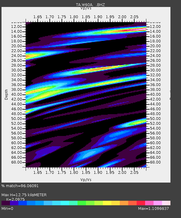
| Estimated Moho Depth: |
12.75 km |
| Estimated Crust Vp/Vs: |
2.10 |
| Assumed Crust Vp: |
6.565 km/s |
| Estimated Crust Vs: |
3.13 km/s |
| Estimated Crust Poisson's Ratio: |
0.35 |
|
| Radial Match: |
96.06091 % |
| Radial Bump: |
400 |
| Transverse Match: |
83.75306 % |
| Transverse Bump: |
400 |
| SOD ConfigId: |
626651 |
| Insert Time: |
2014-04-22 04:59:26.172 +0000 |
| GWidth: |
2.5 |
| Max Bumps: |
400 |
| Tol: |
0.001 |
|
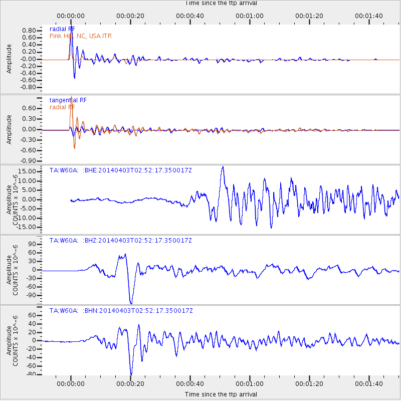
Signal To Noise
| Channel | StoN | STA | LTA |
| TA:W60A: :BHZ:20140403T02:52:17.350017Z | 3.5228133 | 1.2138365E-6 | 3.445645E-7 |
| TA:W60A: :BHN:20140403T02:52:17.350017Z | 2.6518703 | 1.0609951E-6 | 4.0009314E-7 |
| TA:W60A: :BHE:20140403T02:52:17.350017Z | 1.1521302 | 7.91907E-7 | 6.873415E-7 |
| Arrivals |
| Ps | 2.2 SECOND |
| PpPs | 5.7 SECOND |
| PsPs/PpSs | 8.0 SECOND |


