You are here: Home > Network List > US - United States National Seismic Network Stations List
> Station HAWA Hanford, Washington, USA > Earthquake Result Viewer
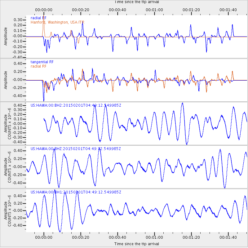
HAWA Hanford, Washington, USA - Earthquake Result Viewer
*The percent match for this event was below the threshold and hence no stack was calculated.
| Earthquake location: |
New Britain Region, P.N.G. |
| Earthquake latitude/longitude: |
-5.4/151.6 |
| Earthquake time(UTC): |
2015/02/01 (032) 04:36:34 GMT |
| Earthquake Depth: |
41 km |
| Earthquake Magnitude: |
5.0 MW |
| Earthquake Catalog/Contributor: |
ISC/ISC |
|
| Network: |
US United States National Seismic Network |
| Station: |
HAWA Hanford, Washington, USA |
| Lat/Lon: |
46.39 N/119.53 W |
| Elevation: |
364 m |
|
| Distance: |
93.1 deg |
| Az: |
43.867 deg |
| Baz: |
265.425 deg |
| Ray Param: |
$rayparam |
*The percent match for this event was below the threshold and hence was not used in the summary stack. |
|
| Radial Match: |
63.46455 % |
| Radial Bump: |
287 |
| Transverse Match: |
63.781853 % |
| Transverse Bump: |
393 |
| SOD ConfigId: |
6964971 |
| Insert Time: |
2019-04-16 08:54:57.556 +0000 |
| GWidth: |
2.5 |
| Max Bumps: |
400 |
| Tol: |
0.001 |
|
Signal To Noise
| Channel | StoN | STA | LTA |
| US:HAWA:00:BHZ:20150201T04:49:12.549985Z | 1.2281923 | 2.4187332E-7 | 1.9693441E-7 |
| US:HAWA:00:BH1:20150201T04:49:12.549985Z | 2.8530595 | 2.96687E-7 | 1.03989066E-7 |
| US:HAWA:00:BH2:20150201T04:49:12.549985Z | 2.39044 | 2.7882194E-7 | 1.1664042E-7 |
| Arrivals |
| Ps | |
| PpPs | |
| PsPs/PpSs | |


