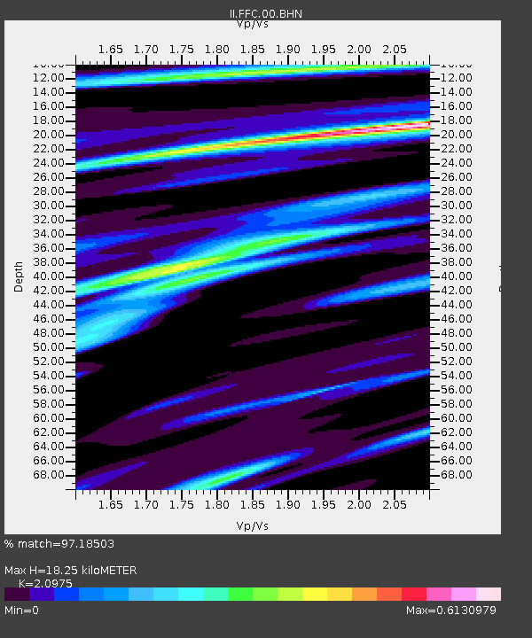
FFC Flin Flon, Canada - Earthquake Result Viewer
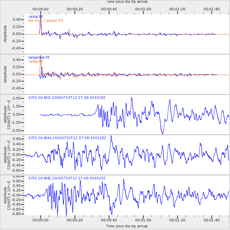
Earthquake location: Southeast Of Honshu, Japan
Earthquake latitude/longitude: 33.9/139.4
Earthquake time(UTC): 2000/07/30 (212) 12:25:45 GMT
Earthquake Depth: 10 km
Earthquake Magnitude: 6.0 MB, 6.5 MS, 6.5 MW, 6.5 MW
Earthquake Catalog/Contributor: WHDF/NEIC
Network: II Global Seismograph Network (GSN - IRIS/IDA)
Station: FFC Flin Flon, Canada
Lat/Lon: 54.72 N/101.98 W
Elevation: 338 m
Distance: 77.2 deg
Az: 31.465 deg
Baz: 311.546 deg
Ray Param: 0.050459143
Estimated Moho Depth: 18.25 km
Estimated Crust Vp/Vs: 2.10
Assumed Crust Vp: 6.552 km/s
Estimated Crust Vs: 3.124 km/s
Estimated Crust Poisson's Ratio: 0.35
Radial Match: 97.18503 %
Radial Bump: 372
Transverse Match: 88.0595 %
Transverse Bump: 400
SOD ConfigId: 3744
Insert Time: 2010-03-01 20:11:27.811 +0000
GWidth: 2.5
Max Bumps: 400
Tol: 0.001

Signal To Noise

ChannelStoNSTALTA
II:FFC:00:BHN:20000730T12:37:08.436028Z2.8298681.2081067E-74.2691273E-8
II:FFC:00:BHE:20000730T12:37:08.436028Z3.59549211.4289729E-73.9743462E-8
II:FFC:00:BHZ:20000730T12:37:08.436028Z7.6018015.104077E-76.7143E-8
Arrivals
Ps3.1 SECOND
PpPs8.4 SECOND
PsPs/PpSs12 SECOND