You are here: Home > Network List > TA - USArray Transportable Network (new EarthScope stations) Stations List
> Station A21K Barrow, AK, USA > Earthquake Result Viewer
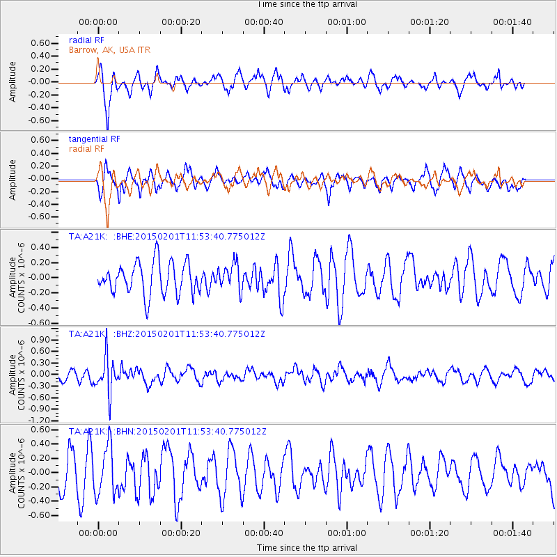
A21K Barrow, AK, USA - Earthquake Result Viewer
*The percent match for this event was below the threshold and hence no stack was calculated.
| Earthquake location: |
Santa Cruz Islands |
| Earthquake latitude/longitude: |
-12.4/166.8 |
| Earthquake time(UTC): |
2015/02/01 (032) 11:41:46 GMT |
| Earthquake Depth: |
179 km |
| Earthquake Magnitude: |
5.4 MW |
| Earthquake Catalog/Contributor: |
ISC/ISC |
|
| Network: |
TA USArray Transportable Network (new EarthScope stations) |
| Station: |
A21K Barrow, AK, USA |
| Lat/Lon: |
71.32 N/156.62 W |
| Elevation: |
577 m |
|
| Distance: |
87.1 deg |
| Az: |
11.084 deg |
| Baz: |
215.654 deg |
| Ray Param: |
$rayparam |
*The percent match for this event was below the threshold and hence was not used in the summary stack. |
|
| Radial Match: |
53.127 % |
| Radial Bump: |
311 |
| Transverse Match: |
51.14506 % |
| Transverse Bump: |
333 |
| SOD ConfigId: |
6970591 |
| Insert Time: |
2019-04-16 09:35:38.062 +0000 |
| GWidth: |
2.5 |
| Max Bumps: |
400 |
| Tol: |
0.001 |
|
Signal To Noise
| Channel | StoN | STA | LTA |
| TA:A21K: :BHZ:20150201T11:53:40.775012Z | 3.8106658 | 4.601995E-7 | 1.2076616E-7 |
| TA:A21K: :BHN:20150201T11:53:40.775012Z | 1.1082764 | 3.4623073E-7 | 3.124047E-7 |
| TA:A21K: :BHE:20150201T11:53:40.775012Z | 0.83732104 | 1.7647892E-7 | 2.1076615E-7 |
| Arrivals |
| Ps | |
| PpPs | |
| PsPs/PpSs | |


