You are here: Home > Network List > TA - USArray Transportable Network (new EarthScope stations) Stations List
> Station D51A Lot 18 Range III Mazenod Township, QC, CAN > Earthquake Result Viewer
D51A Lot 18 Range III Mazenod Township, QC, CAN - Earthquake Result Viewer
| Earthquake location: |
Near Coast Of Northern Chile |
| Earthquake latitude/longitude: |
-20.6/-70.7 |
| Earthquake time(UTC): |
2014/04/03 (093) 03:11:14 GMT |
| Earthquake Depth: |
10 km |
| Earthquake Magnitude: |
5.8 MB |
| Earthquake Catalog/Contributor: |
NEIC PDE/NEIC COMCAT |
|
| Network: |
TA USArray Transportable Network (new EarthScope stations) |
| Station: |
D51A Lot 18 Range III Mazenod Township, QC, CAN |
| Lat/Lon: |
47.09 N/79.37 W |
| Elevation: |
282 m |
|
| Distance: |
67.9 deg |
| Az: |
353.638 deg |
| Baz: |
171.263 deg |
| Ray Param: |
0.056684487 |
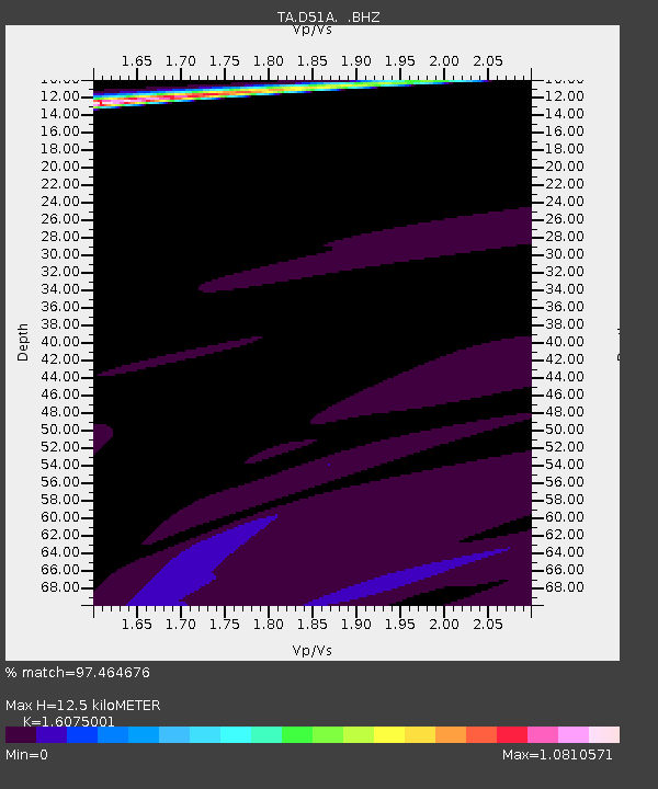
| Estimated Moho Depth: |
12.5 km |
| Estimated Crust Vp/Vs: |
1.61 |
| Assumed Crust Vp: |
6.622 km/s |
| Estimated Crust Vs: |
4.12 km/s |
| Estimated Crust Poisson's Ratio: |
0.18 |
|
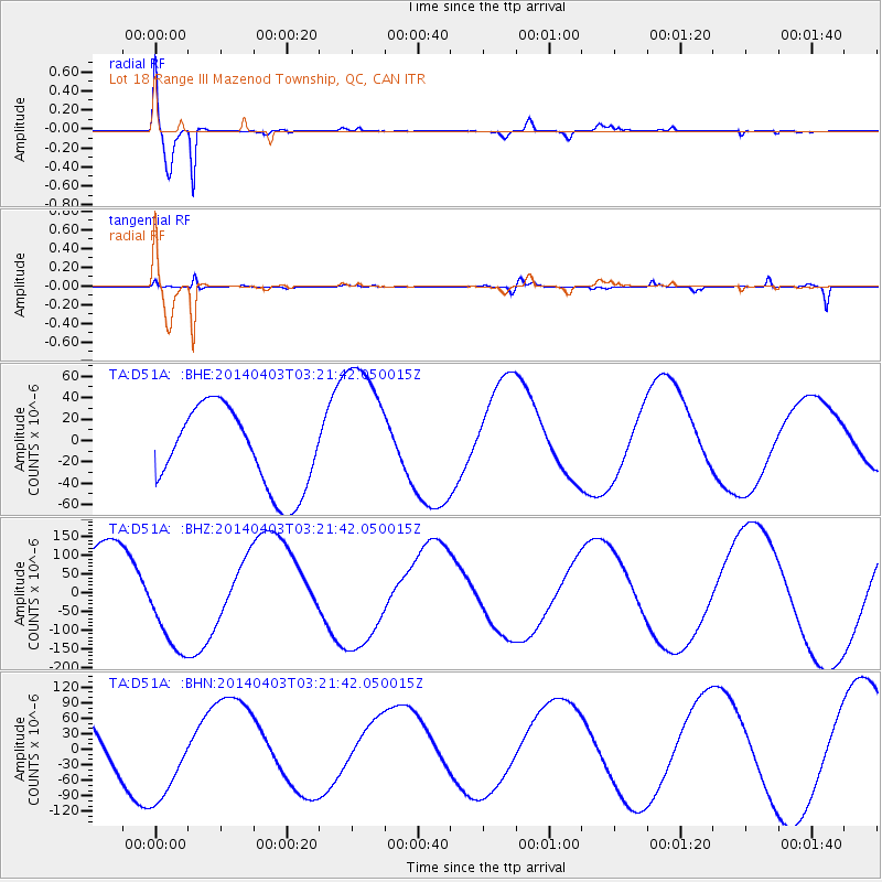
| Radial Match: |
97.464676 % |
| Radial Bump: |
400 |
| Transverse Match: |
80.456024 % |
| Transverse Bump: |
343 |
| SOD ConfigId: |
626651 |
| Insert Time: |
2014-04-22 06:22:38.375 +0000 |
| GWidth: |
2.5 |
| Max Bumps: |
400 |
| Tol: |
0.001 |
|
Signal To Noise
| Channel | StoN | STA | LTA |
| TA:D51A: :BHZ:20140403T03:21:42.050015Z | 1.625935 | 1.3356381E-4 | 8.2145845E-5 |
| TA:D51A: :BHN:20140403T03:21:42.050015Z | 1.7167813 | 8.572085E-5 | 4.9931143E-5 |
| TA:D51A: :BHE:20140403T03:21:42.050015Z | 1.8064747 | 6.818819E-5 | 3.7746548E-5 |
| Arrivals |
| Ps | 1.2 SECOND |
| PpPs | 4.7 SECOND |
| PsPs/PpSs | 5.9 SECOND |


