You are here: Home > Network List > TA - USArray Transportable Network (new EarthScope stations) Stations List
> Station O03E Paynes Creek, CA, USA > Earthquake Result Viewer
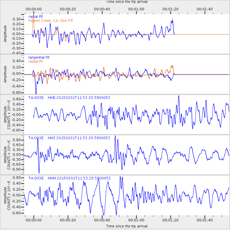
O03E Paynes Creek, CA, USA - Earthquake Result Viewer
*The percent match for this event was below the threshold and hence no stack was calculated.
| Earthquake location: |
Santa Cruz Islands |
| Earthquake latitude/longitude: |
-12.4/166.8 |
| Earthquake time(UTC): |
2015/02/01 (032) 11:41:46 GMT |
| Earthquake Depth: |
179 km |
| Earthquake Magnitude: |
5.4 MW |
| Earthquake Catalog/Contributor: |
ISC/ISC |
|
| Network: |
TA USArray Transportable Network (new EarthScope stations) |
| Station: |
O03E Paynes Creek, CA, USA |
| Lat/Lon: |
40.29 N/121.80 W |
| Elevation: |
967 m |
|
| Distance: |
84.2 deg |
| Az: |
46.768 deg |
| Baz: |
248.519 deg |
| Ray Param: |
$rayparam |
*The percent match for this event was below the threshold and hence was not used in the summary stack. |
|
| Radial Match: |
49.89939 % |
| Radial Bump: |
400 |
| Transverse Match: |
50.936092 % |
| Transverse Bump: |
400 |
| SOD ConfigId: |
6970591 |
| Insert Time: |
2019-04-16 09:36:01.114 +0000 |
| GWidth: |
2.5 |
| Max Bumps: |
400 |
| Tol: |
0.001 |
|
Signal To Noise
| Channel | StoN | STA | LTA |
| TA:O03E: :HHZ:20150201T11:53:26.580005Z | 3.1475198 | 4.0659776E-7 | 1.2918038E-7 |
| TA:O03E: :HHN:20150201T11:53:26.580005Z | 0.66372633 | 1.1508533E-7 | 1.7339275E-7 |
| TA:O03E: :HHE:20150201T11:53:26.580005Z | 1.770566 | 2.12828E-7 | 1.2020337E-7 |
| Arrivals |
| Ps | |
| PpPs | |
| PsPs/PpSs | |


