You are here: Home > Network List > TA - USArray Transportable Network (new EarthScope stations) Stations List
> Station G59A Clarenceville, QC, USA > Earthquake Result Viewer
G59A Clarenceville, QC, USA - Earthquake Result Viewer
| Earthquake location: |
Near Coast Of Northern Chile |
| Earthquake latitude/longitude: |
-20.6/-70.7 |
| Earthquake time(UTC): |
2014/04/03 (093) 03:11:14 GMT |
| Earthquake Depth: |
10 km |
| Earthquake Magnitude: |
5.8 MB |
| Earthquake Catalog/Contributor: |
NEIC PDE/NEIC COMCAT |
|
| Network: |
TA USArray Transportable Network (new EarthScope stations) |
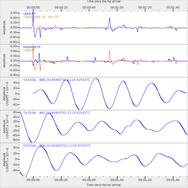
| Station: |
G59A Clarenceville, QC, USA |
| Lat/Lon: |
45.08 N/73.18 W |
| Elevation: |
36 m |
|
| Distance: |
65.4 deg |
| Az: |
358.094 deg |
| Baz: |
177.48 deg |
| Ray Param: |
0.058275018 |
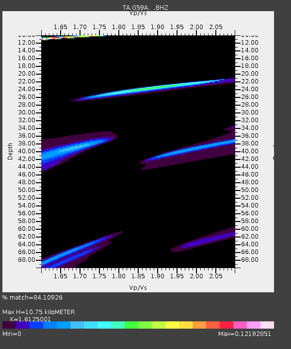
| Estimated Moho Depth: |
10.75 km |
| Estimated Crust Vp/Vs: |
1.61 |
| Assumed Crust Vp: |
6.419 km/s |
| Estimated Crust Vs: |
3.981 km/s |
| Estimated Crust Poisson's Ratio: |
0.19 |
|
| Radial Match: |
84.10926 % |
| Radial Bump: |
400 |
| Transverse Match: |
95.13636 % |
| Transverse Bump: |
203 |
| SOD ConfigId: |
626651 |
| Insert Time: |
2014-04-22 06:24:44.282 +0000 |
| GWidth: |
2.5 |
| Max Bumps: |
400 |
| Tol: |
0.001 |
|
Signal To Noise
| Channel | StoN | STA | LTA |
| TA:G59A: :BHZ:20140403T03:21:26.625027Z | 1.1959865 | 6.276515E-5 | 5.2479816E-5 |
| TA:G59A: :BHN:20140403T03:21:26.625027Z | 0.6750953 | 3.6597863E-5 | 5.4211403E-5 |
| TA:G59A: :BHE:20140403T03:21:26.625027Z | 2.0451825 | 5.302326E-5 | 2.5925932E-5 |
| Arrivals |
| Ps | 1.1 SECOND |
| PpPs | 4.2 SECOND |
| PsPs/PpSs | 5.3 SECOND |


