You are here: Home > Network List > TA - USArray Transportable Network (new EarthScope stations) Stations List
> Station L46A Eue Claire, MI, USA > Earthquake Result Viewer
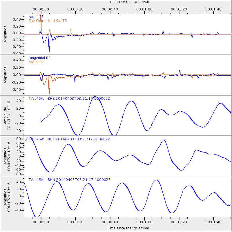
L46A Eue Claire, MI, USA - Earthquake Result Viewer
*The percent match for this event was below the threshold and hence no stack was calculated.
| Earthquake location: |
Near Coast Of Northern Chile |
| Earthquake latitude/longitude: |
-20.6/-70.7 |
| Earthquake time(UTC): |
2014/04/03 (093) 03:11:14 GMT |
| Earthquake Depth: |
10 km |
| Earthquake Magnitude: |
5.8 MB |
| Earthquake Catalog/Contributor: |
NEIC PDE/NEIC COMCAT |
|
| Network: |
TA USArray Transportable Network (new EarthScope stations) |
| Station: |
L46A Eue Claire, MI, USA |
| Lat/Lon: |
42.01 N/86.30 W |
| Elevation: |
223 m |
|
| Distance: |
64.0 deg |
| Az: |
347.144 deg |
| Baz: |
163.761 deg |
| Ray Param: |
$rayparam |
*The percent match for this event was below the threshold and hence was not used in the summary stack. |
|
| Radial Match: |
95.19393 % |
| Radial Bump: |
382 |
| Transverse Match: |
81.13829 % |
| Transverse Bump: |
277 |
| SOD ConfigId: |
626651 |
| Insert Time: |
2014-04-22 06:28:25.385 +0000 |
| GWidth: |
2.5 |
| Max Bumps: |
400 |
| Tol: |
0.001 |
|
Signal To Noise
| Channel | StoN | STA | LTA |
| TA:L46A: :BHZ:20140403T03:21:17.100002Z | 0.7093051 | 5.1059087E-5 | 7.198466E-5 |
| TA:L46A: :BHN:20140403T03:21:17.100002Z | 0.6902268 | 3.336964E-5 | 4.8345904E-5 |
| TA:L46A: :BHE:20140403T03:21:17.100002Z | 1.9822218 | 5.4106717E-5 | 2.7295997E-5 |
| Arrivals |
| Ps | |
| PpPs | |
| PsPs/PpSs | |


