You are here: Home > Network List > TA - USArray Transportable Network (new EarthScope stations) Stations List
> Station O03E Paynes Creek, CA, USA > Earthquake Result Viewer
O03E Paynes Creek, CA, USA - Earthquake Result Viewer
| Earthquake location: |
Near Coast Of Northern Chile |
| Earthquake latitude/longitude: |
-20.6/-70.7 |
| Earthquake time(UTC): |
2014/04/03 (093) 03:11:14 GMT |
| Earthquake Depth: |
10 km |
| Earthquake Magnitude: |
5.8 MB |
| Earthquake Catalog/Contributor: |
NEIC PDE/NEIC COMCAT |
|
| Network: |
TA USArray Transportable Network (new EarthScope stations) |
| Station: |
O03E Paynes Creek, CA, USA |
| Lat/Lon: |
40.29 N/121.80 W |
| Elevation: |
967 m |
|
| Distance: |
77.0 deg |
| Az: |
322.369 deg |
| Baz: |
131.609 deg |
| Ray Param: |
0.050599534 |
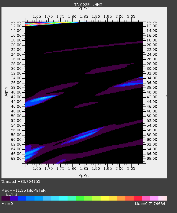
| Estimated Moho Depth: |
11.25 km |
| Estimated Crust Vp/Vs: |
1.60 |
| Assumed Crust Vp: |
6.566 km/s |
| Estimated Crust Vs: |
4.104 km/s |
| Estimated Crust Poisson's Ratio: |
0.18 |
|
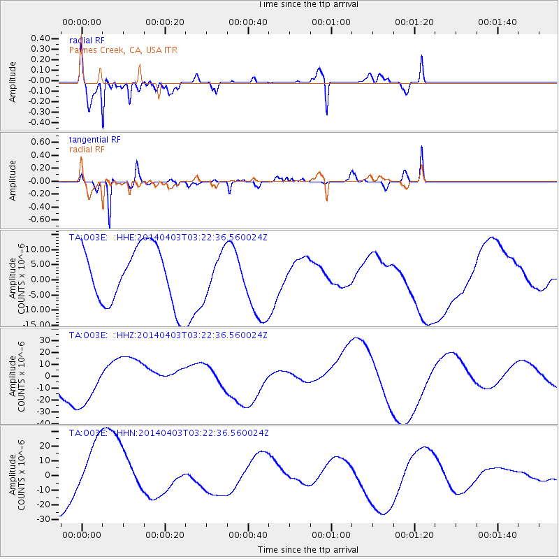
| Radial Match: |
83.704155 % |
| Radial Bump: |
400 |
| Transverse Match: |
87.54907 % |
| Transverse Bump: |
310 |
| SOD ConfigId: |
626651 |
| Insert Time: |
2014-04-22 06:30:34.054 +0000 |
| GWidth: |
2.5 |
| Max Bumps: |
400 |
| Tol: |
0.001 |
|
Signal To Noise
| Channel | StoN | STA | LTA |
| TA:O03E: :HHZ:20140403T03:22:36.560024Z | 1.9624338 | 1.9385914E-5 | 9.878507E-6 |
| TA:O03E: :HHN:20140403T03:22:36.560024Z | 1.9499352 | 2.042867E-5 | 1.0476589E-5 |
| TA:O03E: :HHE:20140403T03:22:36.560024Z | 0.73683137 | 6.874646E-6 | 9.330012E-6 |
| Arrivals |
| Ps | 1.1 SECOND |
| PpPs | 4.3 SECOND |
| PsPs/PpSs | 5.4 SECOND |


