You are here: Home > Network List > TA - USArray Transportable Network (new EarthScope stations) Stations List
> Station U57A Blanch, NC, USA > Earthquake Result Viewer
U57A Blanch, NC, USA - Earthquake Result Viewer
| Earthquake location: |
Near Coast Of Northern Chile |
| Earthquake latitude/longitude: |
-20.6/-70.7 |
| Earthquake time(UTC): |
2014/04/03 (093) 03:11:14 GMT |
| Earthquake Depth: |
10 km |
| Earthquake Magnitude: |
5.8 MB |
| Earthquake Catalog/Contributor: |
NEIC PDE/NEIC COMCAT |
|
| Network: |
TA USArray Transportable Network (new EarthScope stations) |
| Station: |
U57A Blanch, NC, USA |
| Lat/Lon: |
36.43 N/79.34 W |
| Elevation: |
178 m |
|
| Distance: |
57.3 deg |
| Az: |
351.761 deg |
| Baz: |
170.42 deg |
| Ray Param: |
0.063556135 |
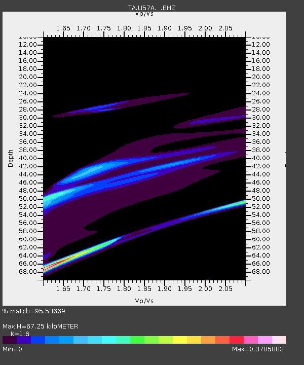
| Estimated Moho Depth: |
67.25 km |
| Estimated Crust Vp/Vs: |
1.60 |
| Assumed Crust Vp: |
6.419 km/s |
| Estimated Crust Vs: |
4.012 km/s |
| Estimated Crust Poisson's Ratio: |
0.18 |
|
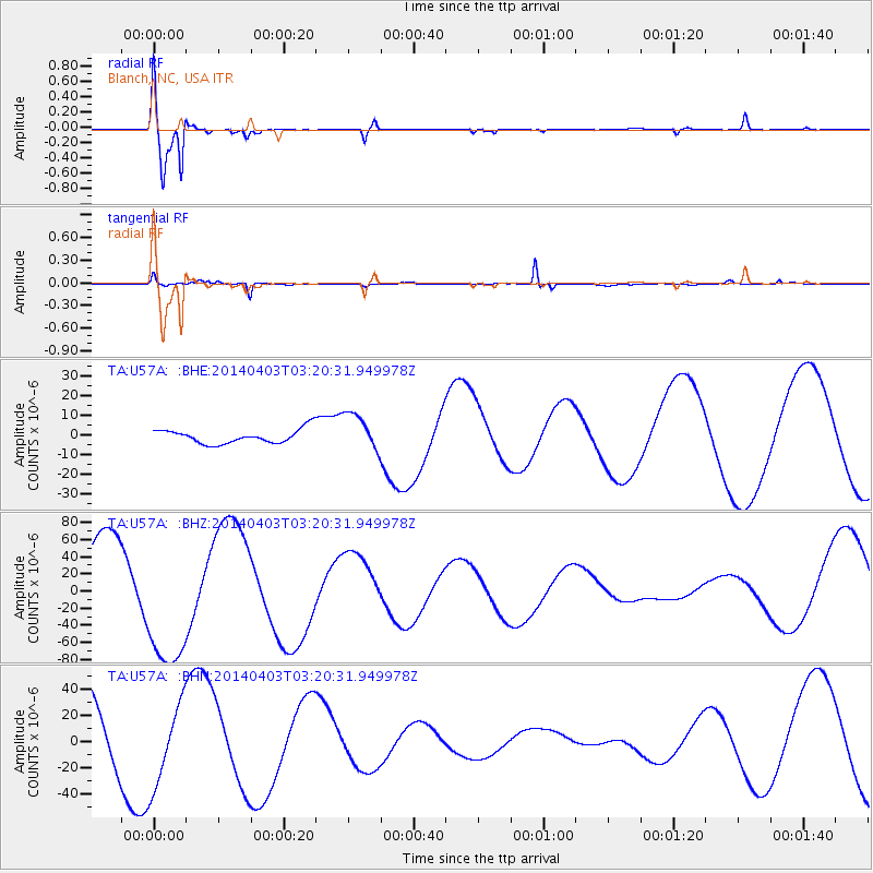
| Radial Match: |
95.53669 % |
| Radial Bump: |
400 |
| Transverse Match: |
72.21638 % |
| Transverse Bump: |
227 |
| SOD ConfigId: |
626651 |
| Insert Time: |
2014-04-22 06:33:40.785 +0000 |
| GWidth: |
2.5 |
| Max Bumps: |
400 |
| Tol: |
0.001 |
|
Signal To Noise
| Channel | StoN | STA | LTA |
| TA:U57A: :BHZ:20140403T03:20:31.949978Z | 1.84374 | 8.095843E-5 | 4.3909895E-5 |
| TA:U57A: :BHN:20140403T03:20:31.949978Z | 1.0008242 | 3.2116513E-5 | 3.2090065E-5 |
| TA:U57A: :BHE:20140403T03:20:31.949978Z | 2.6983488 | 9.736407E-6 | 3.6082834E-6 |
| Arrivals |
| Ps | 6.6 SECOND |
| PpPs | 26 SECOND |
| PsPs/PpSs | 32 SECOND |


