You are here: Home > Network List > US - United States National Seismic Network Stations List
> Station HAWA Hanford, Washington, USA > Earthquake Result Viewer
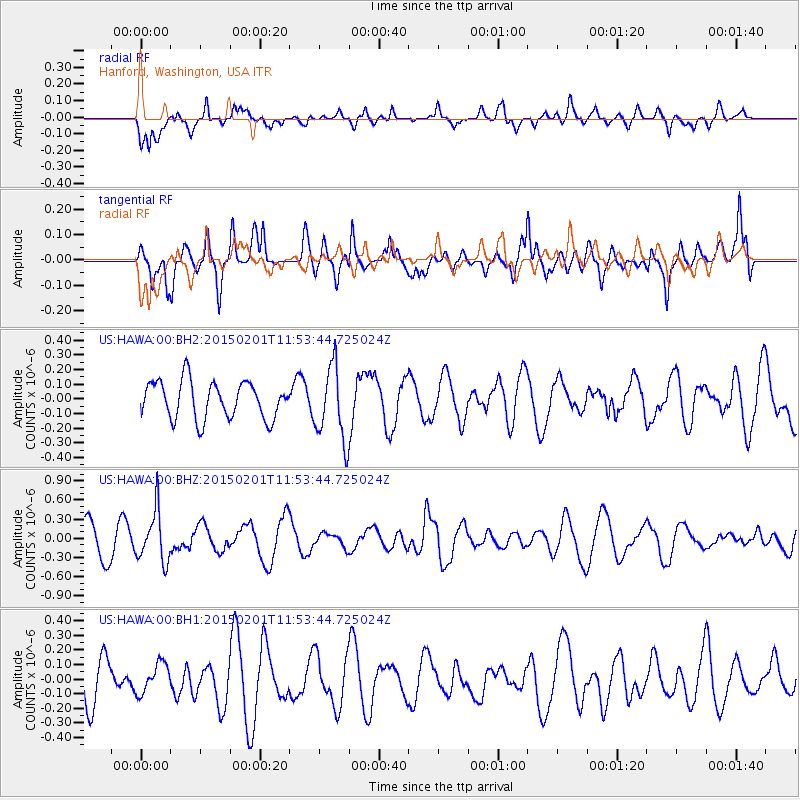
HAWA Hanford, Washington, USA - Earthquake Result Viewer
*The percent match for this event was below the threshold and hence no stack was calculated.
| Earthquake location: |
Santa Cruz Islands |
| Earthquake latitude/longitude: |
-12.4/166.8 |
| Earthquake time(UTC): |
2015/02/01 (032) 11:41:46 GMT |
| Earthquake Depth: |
179 km |
| Earthquake Magnitude: |
5.4 MW |
| Earthquake Catalog/Contributor: |
ISC/ISC |
|
| Network: |
US United States National Seismic Network |
| Station: |
HAWA Hanford, Washington, USA |
| Lat/Lon: |
46.39 N/119.53 W |
| Elevation: |
364 m |
|
| Distance: |
87.9 deg |
| Az: |
41.654 deg |
| Baz: |
249.724 deg |
| Ray Param: |
$rayparam |
*The percent match for this event was below the threshold and hence was not used in the summary stack. |
|
| Radial Match: |
48.848557 % |
| Radial Bump: |
370 |
| Transverse Match: |
52.725037 % |
| Transverse Bump: |
390 |
| SOD ConfigId: |
6970591 |
| Insert Time: |
2019-04-16 09:37:29.502 +0000 |
| GWidth: |
2.5 |
| Max Bumps: |
400 |
| Tol: |
0.001 |
|
Signal To Noise
| Channel | StoN | STA | LTA |
| US:HAWA:00:BHZ:20150201T11:53:44.725024Z | 2.3491828 | 3.9434735E-7 | 1.6786575E-7 |
| US:HAWA:00:BH1:20150201T11:53:44.725024Z | 0.6004072 | 1.01809874E-7 | 1.6956805E-7 |
| US:HAWA:00:BH2:20150201T11:53:44.725024Z | 2.0131614 | 2.55095E-7 | 1.2671362E-7 |
| Arrivals |
| Ps | |
| PpPs | |
| PsPs/PpSs | |


