You are here: Home > Network List > PB - Plate Boundary Observatory Borehole Seismic Network Stations List
> Station B081 keenwi081bcs2006, Anza, CA, USA > Earthquake Result Viewer
B081 keenwi081bcs2006, Anza, CA, USA - Earthquake Result Viewer
| Earthquake location: |
Near Coast Of Northern Chile |
| Earthquake latitude/longitude: |
-20.8/-70.5 |
| Earthquake time(UTC): |
2014/04/03 (093) 05:26:16 GMT |
| Earthquake Depth: |
24 km |
| Earthquake Magnitude: |
6.2 MWP, 6.2 MWR, 6.3 MWW, 6.5 MWC |
| Earthquake Catalog/Contributor: |
NEIC PDE/NEIC COMCAT |
|
| Network: |
PB Plate Boundary Observatory Borehole Seismic Network |
| Station: |
B081 keenwi081bcs2006, Anza, CA, USA |
| Lat/Lon: |
33.71 N/116.71 W |
| Elevation: |
1467 m |
|
| Distance: |
69.8 deg |
| Az: |
320.162 deg |
| Baz: |
134.026 deg |
| Ray Param: |
0.0553648 |
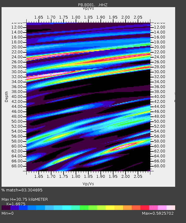
| Estimated Moho Depth: |
30.75 km |
| Estimated Crust Vp/Vs: |
1.70 |
| Assumed Crust Vp: |
6.264 km/s |
| Estimated Crust Vs: |
3.69 km/s |
| Estimated Crust Poisson's Ratio: |
0.23 |
|
| Radial Match: |
83.304695 % |
| Radial Bump: |
400 |
| Transverse Match: |
80.38577 % |
| Transverse Bump: |
400 |
| SOD ConfigId: |
626651 |
| Insert Time: |
2014-04-22 07:08:57.312 +0000 |
| GWidth: |
2.5 |
| Max Bumps: |
400 |
| Tol: |
0.001 |
|

Signal To Noise
| Channel | StoN | STA | LTA |
| PB:B081: :HHZ:20140403T05:36:53.283989Z | 3.0257645 | 9.411752E-9 | 3.1105372E-9 |
| PB:B081: :HH1:20140403T05:36:53.283989Z | 1.0624653 | 1.0169183E-9 | 9.571308E-10 |
| PB:B081: :HH2:20140403T05:36:53.283989Z | 1.8903042 | 4.4925397E-9 | 2.3766225E-9 |
| Arrivals |
| Ps | 3.6 SECOND |
| PpPs | 13 SECOND |
| PsPs/PpSs | 16 SECOND |


