You are here: Home > Network List > TA - USArray Transportable Network (new EarthScope stations) Stations List
> Station H65A Eastbrook, ME, USA > Earthquake Result Viewer
H65A Eastbrook, ME, USA - Earthquake Result Viewer
| Earthquake location: |
Near Coast Of Northern Chile |
| Earthquake latitude/longitude: |
-20.8/-70.5 |
| Earthquake time(UTC): |
2014/04/03 (093) 05:26:16 GMT |
| Earthquake Depth: |
24 km |
| Earthquake Magnitude: |
6.2 MWP, 6.2 MWR, 6.3 MWW, 6.5 MWC |
| Earthquake Catalog/Contributor: |
NEIC PDE/NEIC COMCAT |
|
| Network: |
TA USArray Transportable Network (new EarthScope stations) |
| Station: |
H65A Eastbrook, ME, USA |
| Lat/Lon: |
44.70 N/68.25 W |
| Elevation: |
98 m |
|
| Distance: |
65.2 deg |
| Az: |
1.808 deg |
| Baz: |
182.372 deg |
| Ray Param: |
0.058385156 |
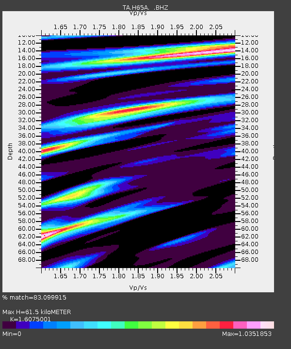
| Estimated Moho Depth: |
61.5 km |
| Estimated Crust Vp/Vs: |
1.61 |
| Assumed Crust Vp: |
6.419 km/s |
| Estimated Crust Vs: |
3.993 km/s |
| Estimated Crust Poisson's Ratio: |
0.18 |
|
| Radial Match: |
83.099915 % |
| Radial Bump: |
400 |
| Transverse Match: |
81.862724 % |
| Transverse Bump: |
392 |
| SOD ConfigId: |
626651 |
| Insert Time: |
2014-04-22 07:19:53.492 +0000 |
| GWidth: |
2.5 |
| Max Bumps: |
400 |
| Tol: |
0.001 |
|

Signal To Noise
| Channel | StoN | STA | LTA |
| TA:H65A: :BHZ:20140403T05:36:24.325005Z | 2.4246151 | 2.402156E-6 | 9.90737E-7 |
| TA:H65A: :BHN:20140403T05:36:24.325005Z | 1.132461 | 1.1510928E-6 | 1.0164525E-6 |
| TA:H65A: :BHE:20140403T05:36:24.325005Z | 2.2301233 | 2.1090573E-6 | 9.457134E-7 |
| Arrivals |
| Ps | 6.1 SECOND |
| PpPs | 24 SECOND |
| PsPs/PpSs | 30 SECOND |


