You are here: Home > Network List > TA - USArray Transportable Network (new EarthScope stations) Stations List
> Station I49A Point Hope, MI, USA > Earthquake Result Viewer
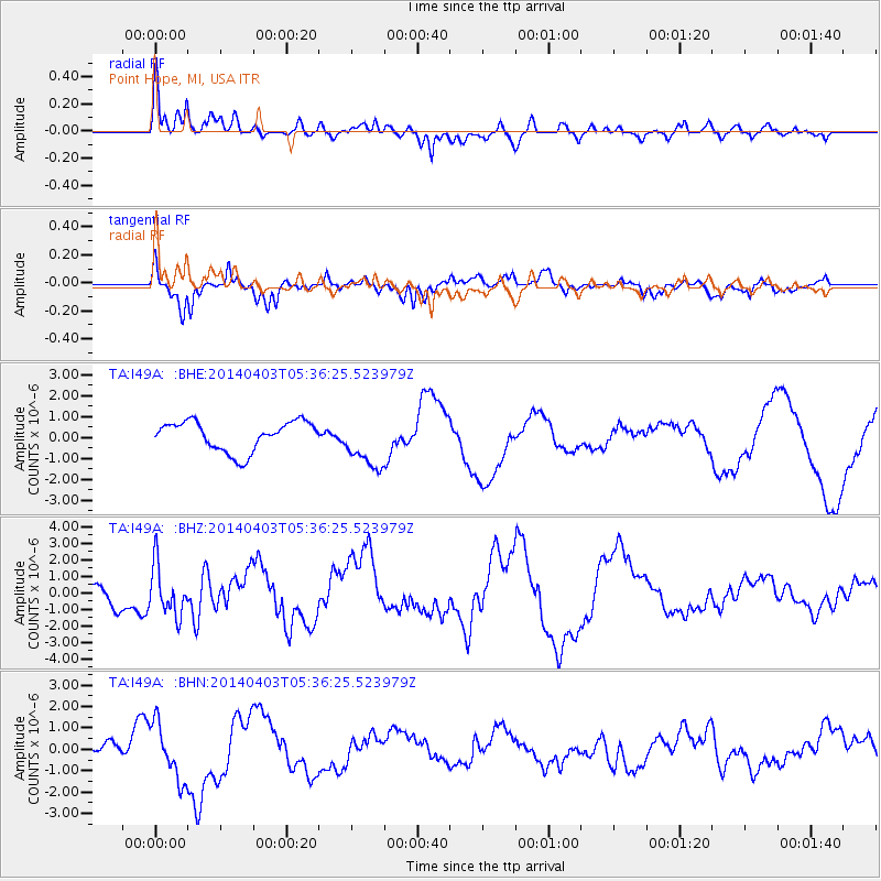
I49A Point Hope, MI, USA - Earthquake Result Viewer
*The percent match for this event was below the threshold and hence no stack was calculated.
| Earthquake location: |
Near Coast Of Northern Chile |
| Earthquake latitude/longitude: |
-20.8/-70.5 |
| Earthquake time(UTC): |
2014/04/03 (093) 05:26:16 GMT |
| Earthquake Depth: |
24 km |
| Earthquake Magnitude: |
6.2 MWP, 6.2 MWR, 6.3 MWW, 6.5 MWC |
| Earthquake Catalog/Contributor: |
NEIC PDE/NEIC COMCAT |
|
| Network: |
TA USArray Transportable Network (new EarthScope stations) |
| Station: |
I49A Point Hope, MI, USA |
| Lat/Lon: |
43.94 N/82.82 W |
| Elevation: |
217 m |
|
| Distance: |
65.4 deg |
| Az: |
350.275 deg |
| Baz: |
167.363 deg |
| Ray Param: |
$rayparam |
*The percent match for this event was below the threshold and hence was not used in the summary stack. |
|
| Radial Match: |
57.521114 % |
| Radial Bump: |
400 |
| Transverse Match: |
71.33585 % |
| Transverse Bump: |
322 |
| SOD ConfigId: |
626651 |
| Insert Time: |
2014-04-22 07:20:46.858 +0000 |
| GWidth: |
2.5 |
| Max Bumps: |
400 |
| Tol: |
0.001 |
|
Signal To Noise
| Channel | StoN | STA | LTA |
| TA:I49A: :BHZ:20140403T05:36:25.523979Z | 2.0886848 | 1.5089562E-6 | 7.224432E-7 |
| TA:I49A: :BHN:20140403T05:36:25.523979Z | 2.7975726 | 1.3058738E-6 | 4.6678818E-7 |
| TA:I49A: :BHE:20140403T05:36:25.523979Z | 1.770137 | 1.2529802E-6 | 7.078436E-7 |
| Arrivals |
| Ps | |
| PpPs | |
| PsPs/PpSs | |


