You are here: Home > Network List > TA - USArray Transportable Network (new EarthScope stations) Stations List
> Station J54A Appleton, NY, USA > Earthquake Result Viewer
J54A Appleton, NY, USA - Earthquake Result Viewer
| Earthquake location: |
Near Coast Of Northern Chile |
| Earthquake latitude/longitude: |
-20.8/-70.5 |
| Earthquake time(UTC): |
2014/04/03 (093) 05:26:16 GMT |
| Earthquake Depth: |
24 km |
| Earthquake Magnitude: |
6.2 MWP, 6.2 MWR, 6.3 MWW, 6.5 MWC |
| Earthquake Catalog/Contributor: |
NEIC PDE/NEIC COMCAT |
|
| Network: |
TA USArray Transportable Network (new EarthScope stations) |
| Station: |
J54A Appleton, NY, USA |
| Lat/Lon: |
43.27 N/78.64 W |
| Elevation: |
112 m |
|
| Distance: |
64.2 deg |
| Az: |
353.444 deg |
| Baz: |
171.59 deg |
| Ray Param: |
0.059047174 |
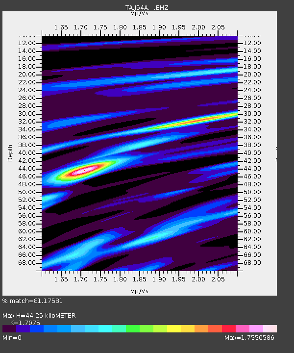
| Estimated Moho Depth: |
44.25 km |
| Estimated Crust Vp/Vs: |
1.71 |
| Assumed Crust Vp: |
6.419 km/s |
| Estimated Crust Vs: |
3.759 km/s |
| Estimated Crust Poisson's Ratio: |
0.24 |
|
| Radial Match: |
81.17581 % |
| Radial Bump: |
400 |
| Transverse Match: |
59.259636 % |
| Transverse Bump: |
308 |
| SOD ConfigId: |
626651 |
| Insert Time: |
2014-04-22 07:22:06.154 +0000 |
| GWidth: |
2.5 |
| Max Bumps: |
400 |
| Tol: |
0.001 |
|
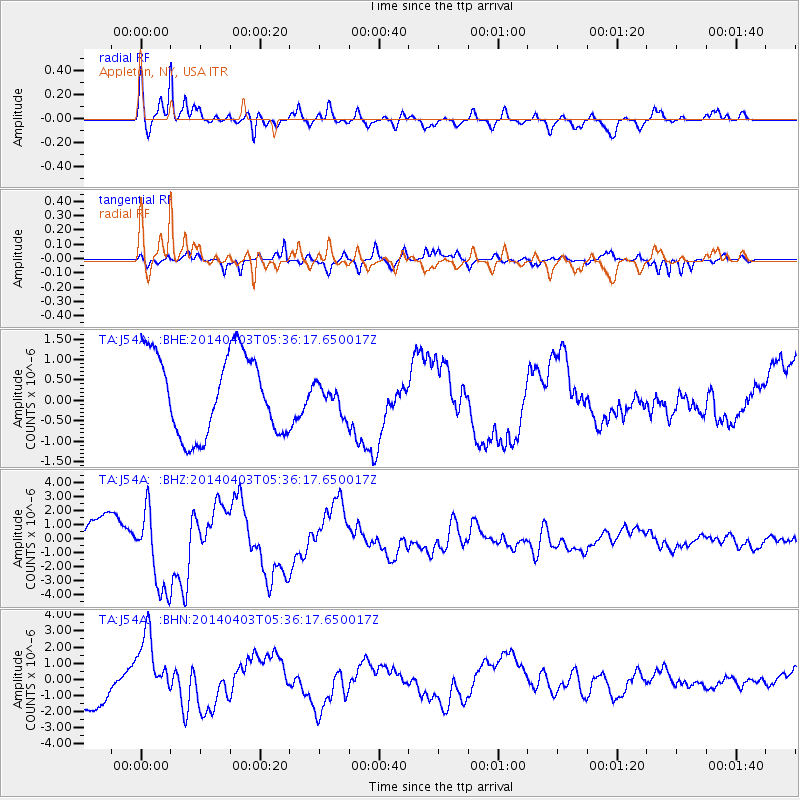
Signal To Noise
| Channel | StoN | STA | LTA |
| TA:J54A: :BHZ:20140403T05:36:17.650017Z | 2.1549528 | 2.9598623E-6 | 1.3735162E-6 |
| TA:J54A: :BHN:20140403T05:36:17.650017Z | 1.6933345 | 2.0764892E-6 | 1.2262724E-6 |
| TA:J54A: :BHE:20140403T05:36:17.650017Z | 0.35309812 | 3.4784964E-7 | 9.851359E-7 |
| Arrivals |
| Ps | 5.1 SECOND |
| PpPs | 18 SECOND |
| PsPs/PpSs | 23 SECOND |


