You are here: Home > Network List > TA - USArray Transportable Network (new EarthScope stations) Stations List
> Station M53A WI Miller and Sons, Farmdale, OH, USA > Earthquake Result Viewer
M53A WI Miller and Sons, Farmdale, OH, USA - Earthquake Result Viewer

| Earthquake location: |
Near Coast Of Northern Chile |
| Earthquake latitude/longitude: |
-20.8/-70.5 |
| Earthquake time(UTC): |
2014/04/03 (093) 05:26:16 GMT |
| Earthquake Depth: |
24 km |
| Earthquake Magnitude: |
6.2 MWP, 6.2 MWR, 6.3 MWW, 6.5 MWC |
| Earthquake Catalog/Contributor: |
NEIC PDE/NEIC COMCAT |
|
| Network: |
TA USArray Transportable Network (new EarthScope stations) |
| Station: |
M53A WI Miller and Sons, Farmdale, OH, USA |
| Lat/Lon: |
41.44 N/80.68 W |
| Elevation: |
334 m |
|
| Distance: |
62.6 deg |
| Az: |
351.44 deg |
| Baz: |
169.326 deg |
| Ray Param: |
0.060063228 |
| Estimated Moho Depth: |
59.75 km |
| Estimated Crust Vp/Vs: |
1.66 |
| Assumed Crust Vp: |
6.483 km/s |
| Estimated Crust Vs: |
3.911 km/s |
| Estimated Crust Poisson's Ratio: |
0.21 |
|
| Radial Match: |
84.83995 % |
| Radial Bump: |
356 |
| Transverse Match: |
67.457306 % |
| Transverse Bump: |
394 |
| SOD ConfigId: |
626651 |
| Insert Time: |
2014-04-22 07:25:59.040 +0000 |
| GWidth: |
2.5 |
| Max Bumps: |
400 |
| Tol: |
0.001 |
|
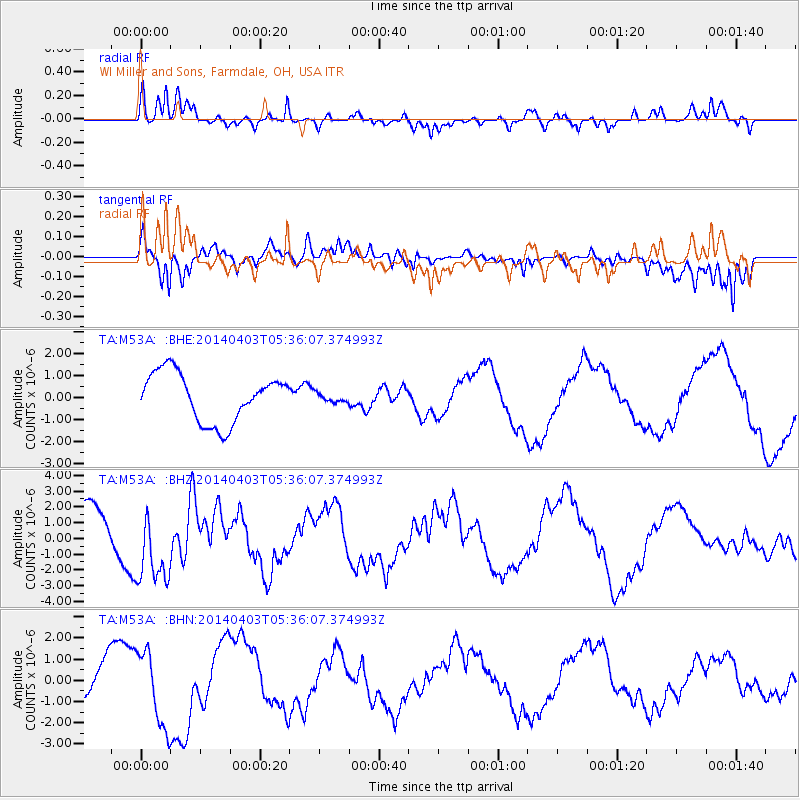
Signal To Noise
| Channel | StoN | STA | LTA |
| TA:M53A: :BHZ:20140403T05:36:07.374993Z | 2.1838067 | 2.5336772E-6 | 1.1602112E-6 |
| TA:M53A: :BHN:20140403T05:36:07.374993Z | 1.0925531 | 1.7730882E-6 | 1.6228852E-6 |
| TA:M53A: :BHE:20140403T05:36:07.374993Z | 0.18538253 | 2.0151685E-7 | 1.0870326E-6 |
| Arrivals |
| Ps | 6.4 SECOND |
| PpPs | 23 SECOND |
| PsPs/PpSs | 30 SECOND |


