You are here: Home > Network List > TA - USArray Transportable Network (new EarthScope stations) Stations List
> Station S56A Natural Bridge, VA, USA > Earthquake Result Viewer
S56A Natural Bridge, VA, USA - Earthquake Result Viewer
| Earthquake location: |
Near Coast Of Northern Chile |
| Earthquake latitude/longitude: |
-20.8/-70.5 |
| Earthquake time(UTC): |
2014/04/03 (093) 05:26:16 GMT |
| Earthquake Depth: |
24 km |
| Earthquake Magnitude: |
6.2 MWP, 6.2 MWR, 6.3 MWW, 6.5 MWC |
| Earthquake Catalog/Contributor: |
NEIC PDE/NEIC COMCAT |
|
| Network: |
TA USArray Transportable Network (new EarthScope stations) |
| Station: |
S56A Natural Bridge, VA, USA |
| Lat/Lon: |
37.68 N/79.57 W |
| Elevation: |
449 m |
|
| Distance: |
58.8 deg |
| Az: |
351.639 deg |
| Baz: |
170.127 deg |
| Ray Param: |
0.0625826 |
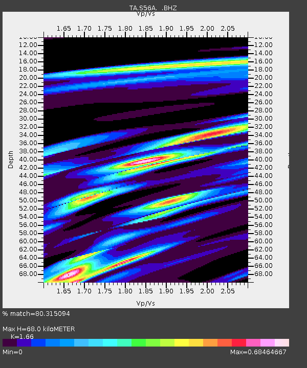
| Estimated Moho Depth: |
68.0 km |
| Estimated Crust Vp/Vs: |
1.66 |
| Assumed Crust Vp: |
6.419 km/s |
| Estimated Crust Vs: |
3.867 km/s |
| Estimated Crust Poisson's Ratio: |
0.22 |
|
| Radial Match: |
80.315094 % |
| Radial Bump: |
400 |
| Transverse Match: |
58.348095 % |
| Transverse Bump: |
400 |
| SOD ConfigId: |
626651 |
| Insert Time: |
2014-04-22 07:32:12.035 +0000 |
| GWidth: |
2.5 |
| Max Bumps: |
400 |
| Tol: |
0.001 |
|
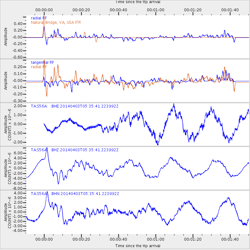
Signal To Noise
| Channel | StoN | STA | LTA |
| TA:S56A: :BHZ:20140403T05:35:41.223992Z | 2.4512553 | 4.6667087E-6 | 1.9038036E-6 |
| TA:S56A: :BHN:20140403T05:35:41.223992Z | 1.8331244 | 2.4638039E-6 | 1.3440462E-6 |
| TA:S56A: :BHE:20140403T05:35:41.223992Z | 0.9433437 | 3.874328E-7 | 4.1070166E-7 |
| Arrivals |
| Ps | 7.4 SECOND |
| PpPs | 27 SECOND |
| PsPs/PpSs | 34 SECOND |


