You are here: Home > Network List > TA - USArray Transportable Network (new EarthScope stations) Stations List
> Station S60A Water View, VA, USA > Earthquake Result Viewer
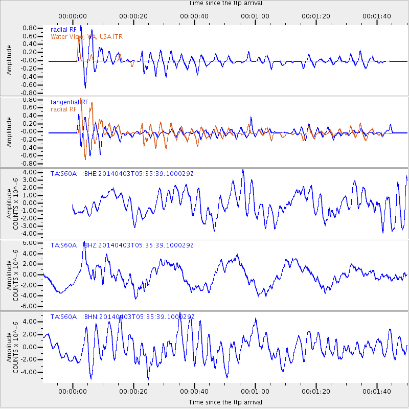
S60A Water View, VA, USA - Earthquake Result Viewer
*The percent match for this event was below the threshold and hence no stack was calculated.
| Earthquake location: |
Near Coast Of Northern Chile |
| Earthquake latitude/longitude: |
-20.8/-70.5 |
| Earthquake time(UTC): |
2014/04/03 (093) 05:26:16 GMT |
| Earthquake Depth: |
24 km |
| Earthquake Magnitude: |
6.2 MWP, 6.2 MWR, 6.3 MWW, 6.5 MWC |
| Earthquake Catalog/Contributor: |
NEIC PDE/NEIC COMCAT |
|
| Network: |
TA USArray Transportable Network (new EarthScope stations) |
| Station: |
S60A Water View, VA, USA |
| Lat/Lon: |
37.42 N/76.39 W |
| Elevation: |
36 m |
|
| Distance: |
58.2 deg |
| Az: |
354.526 deg |
| Baz: |
173.564 deg |
| Ray Param: |
$rayparam |
*The percent match for this event was below the threshold and hence was not used in the summary stack. |
|
| Radial Match: |
85.313614 % |
| Radial Bump: |
400 |
| Transverse Match: |
62.702454 % |
| Transverse Bump: |
400 |
| SOD ConfigId: |
626651 |
| Insert Time: |
2014-04-22 07:32:22.016 +0000 |
| GWidth: |
2.5 |
| Max Bumps: |
400 |
| Tol: |
0.001 |
|
Signal To Noise
| Channel | StoN | STA | LTA |
| TA:S60A: :BHZ:20140403T05:35:39.100029Z | 1.6495557 | 2.7084393E-6 | 1.6419206E-6 |
| TA:S60A: :BHN:20140403T05:35:39.100029Z | 1.2100528 | 2.0402204E-6 | 1.6860589E-6 |
| TA:S60A: :BHE:20140403T05:35:39.100029Z | 1.0253375 | 1.2102558E-6 | 1.1803488E-6 |
| Arrivals |
| Ps | |
| PpPs | |
| PsPs/PpSs | |


