You are here: Home > Network List > TA - USArray Transportable Network (new EarthScope stations) Stations List
> Station V56A Mocksville, NC, USA > Earthquake Result Viewer
V56A Mocksville, NC, USA - Earthquake Result Viewer
| Earthquake location: |
Near Coast Of Northern Chile |
| Earthquake latitude/longitude: |
-20.8/-70.5 |
| Earthquake time(UTC): |
2014/04/03 (093) 05:26:16 GMT |
| Earthquake Depth: |
24 km |
| Earthquake Magnitude: |
6.2 MWP, 6.2 MWR, 6.3 MWW, 6.5 MWC |
| Earthquake Catalog/Contributor: |
NEIC PDE/NEIC COMCAT |
|
| Network: |
TA USArray Transportable Network (new EarthScope stations) |
| Station: |
V56A Mocksville, NC, USA |
| Lat/Lon: |
35.81 N/80.50 W |
| Elevation: |
237 m |
|
| Distance: |
57.1 deg |
| Az: |
350.372 deg |
| Baz: |
168.901 deg |
| Ray Param: |
0.063678734 |
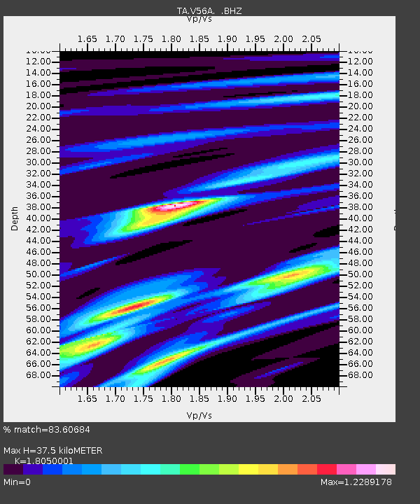
| Estimated Moho Depth: |
37.5 km |
| Estimated Crust Vp/Vs: |
1.81 |
| Assumed Crust Vp: |
6.419 km/s |
| Estimated Crust Vs: |
3.556 km/s |
| Estimated Crust Poisson's Ratio: |
0.28 |
|
| Radial Match: |
83.60684 % |
| Radial Bump: |
264 |
| Transverse Match: |
66.52324 % |
| Transverse Bump: |
319 |
| SOD ConfigId: |
626651 |
| Insert Time: |
2014-04-22 07:33:55.425 +0000 |
| GWidth: |
2.5 |
| Max Bumps: |
400 |
| Tol: |
0.001 |
|

Signal To Noise
| Channel | StoN | STA | LTA |
| TA:V56A: :BHZ:20140403T05:35:29.350029Z | 1.979951 | 3.7984976E-6 | 1.9184806E-6 |
| TA:V56A: :BHN:20140403T05:35:29.350029Z | 1.641227 | 2.368472E-6 | 1.4431106E-6 |
| TA:V56A: :BHE:20140403T05:35:29.350029Z | 2.4433854 | 2.1890417E-6 | 8.959052E-7 |
| Arrivals |
| Ps | 4.9 SECOND |
| PpPs | 16 SECOND |
| PsPs/PpSs | 21 SECOND |


