You are here: Home > Network List > TA - USArray Transportable Network (new EarthScope stations) Stations List
> Station W56A Indian Trail, NC, USA > Earthquake Result Viewer
W56A Indian Trail, NC, USA - Earthquake Result Viewer
| Earthquake location: |
Near Coast Of Northern Chile |
| Earthquake latitude/longitude: |
-20.8/-70.5 |
| Earthquake time(UTC): |
2014/04/03 (093) 05:26:16 GMT |
| Earthquake Depth: |
24 km |
| Earthquake Magnitude: |
6.2 MWP, 6.2 MWR, 6.3 MWW, 6.5 MWC |
| Earthquake Catalog/Contributor: |
NEIC PDE/NEIC COMCAT |
|
| Network: |
TA USArray Transportable Network (new EarthScope stations) |
| Station: |
W56A Indian Trail, NC, USA |
| Lat/Lon: |
35.13 N/80.58 W |
| Elevation: |
177 m |
|
| Distance: |
56.4 deg |
| Az: |
350.133 deg |
| Baz: |
168.72 deg |
| Ray Param: |
0.06410309 |
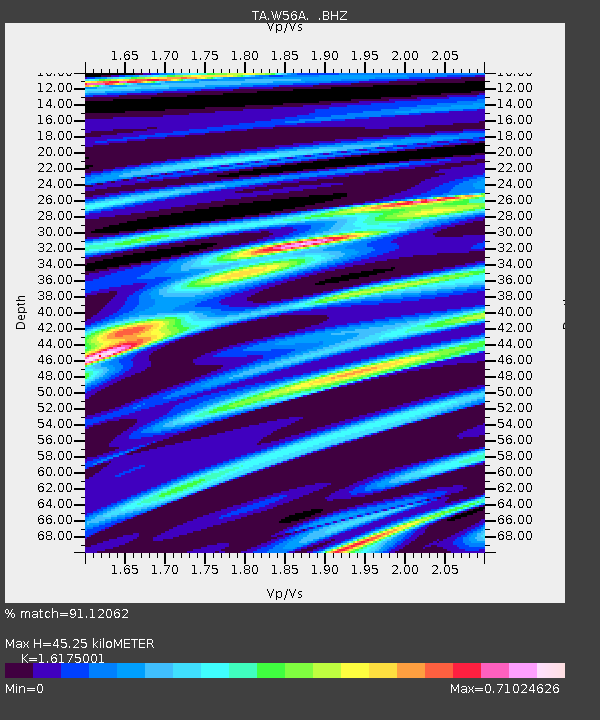
| Estimated Moho Depth: |
45.25 km |
| Estimated Crust Vp/Vs: |
1.62 |
| Assumed Crust Vp: |
6.419 km/s |
| Estimated Crust Vs: |
3.969 km/s |
| Estimated Crust Poisson's Ratio: |
0.19 |
|
| Radial Match: |
91.12062 % |
| Radial Bump: |
400 |
| Transverse Match: |
82.994995 % |
| Transverse Bump: |
400 |
| SOD ConfigId: |
626651 |
| Insert Time: |
2014-04-22 07:34:29.494 +0000 |
| GWidth: |
2.5 |
| Max Bumps: |
400 |
| Tol: |
0.001 |
|

Signal To Noise
| Channel | StoN | STA | LTA |
| TA:W56A: :BHZ:20140403T05:35:24.775017Z | 2.214097 | 3.9491724E-6 | 1.783649E-6 |
| TA:W56A: :BHN:20140403T05:35:24.775017Z | 1.1068145 | 1.6174079E-6 | 1.4613179E-6 |
| TA:W56A: :BHE:20140403T05:35:24.775017Z | 1.4547876 | 6.491137E-7 | 4.461914E-7 |
| Arrivals |
| Ps | 4.6 SECOND |
| PpPs | 17 SECOND |
| PsPs/PpSs | 22 SECOND |


