You are here: Home > Network List > TA - USArray Transportable Network (new EarthScope stations) Stations List
> Station W57A Gilead, NC, USA > Earthquake Result Viewer
W57A Gilead, NC, USA - Earthquake Result Viewer

| Earthquake location: |
Near Coast Of Northern Chile |
| Earthquake latitude/longitude: |
-20.8/-70.5 |
| Earthquake time(UTC): |
2014/04/03 (093) 05:26:16 GMT |
| Earthquake Depth: |
24 km |
| Earthquake Magnitude: |
6.2 MWP, 6.2 MWR, 6.3 MWW, 6.5 MWC |
| Earthquake Catalog/Contributor: |
NEIC PDE/NEIC COMCAT |
|
| Network: |
TA USArray Transportable Network (new EarthScope stations) |
| Station: |
W57A Gilead, NC, USA |
| Lat/Lon: |
35.15 N/79.99 W |
| Elevation: |
85 m |
|
| Distance: |
56.4 deg |
| Az: |
350.707 deg |
| Baz: |
169.375 deg |
| Ray Param: |
0.064151466 |
| Estimated Moho Depth: |
36.5 km |
| Estimated Crust Vp/Vs: |
1.75 |
| Assumed Crust Vp: |
6.565 km/s |
| Estimated Crust Vs: |
3.74 km/s |
| Estimated Crust Poisson's Ratio: |
0.26 |
|
| Radial Match: |
83.85091 % |
| Radial Bump: |
400 |
| Transverse Match: |
76.665 % |
| Transverse Bump: |
400 |
| SOD ConfigId: |
626651 |
| Insert Time: |
2014-04-22 07:34:33.024 +0000 |
| GWidth: |
2.5 |
| Max Bumps: |
400 |
| Tol: |
0.001 |
|
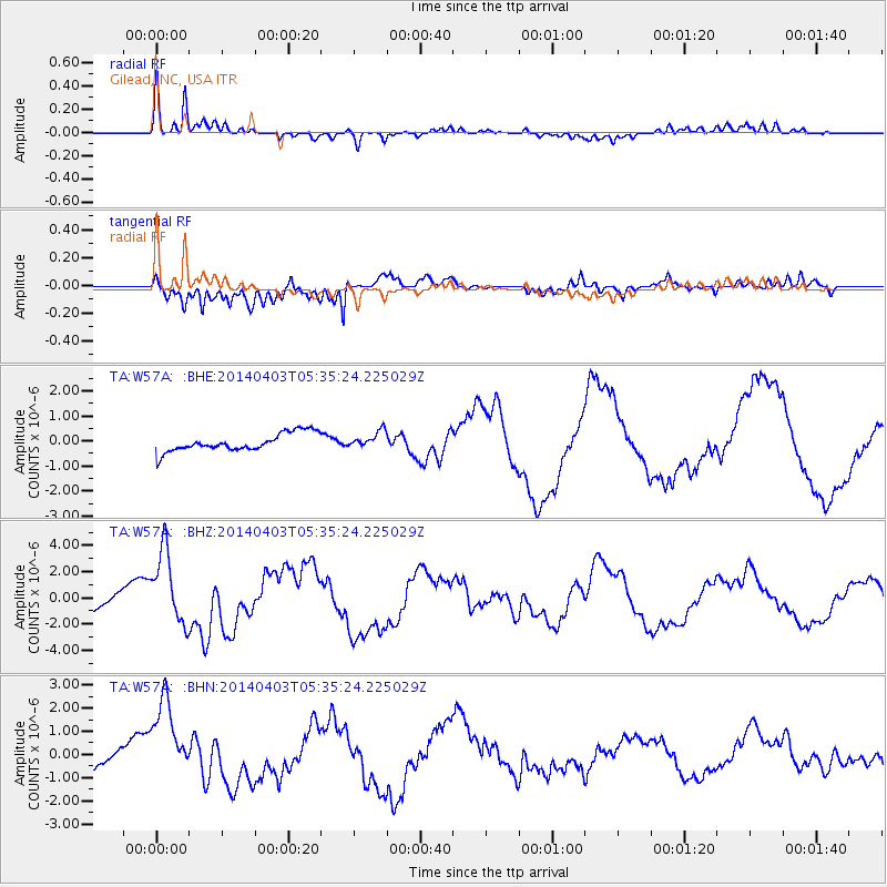
Signal To Noise
| Channel | StoN | STA | LTA |
| TA:W57A: :BHZ:20140403T05:35:24.225029Z | 2.9669294 | 2.8051857E-6 | 9.454845E-7 |
| TA:W57A: :BHN:20140403T05:35:24.225029Z | 2.6831975 | 1.7533447E-6 | 6.5345347E-7 |
| TA:W57A: :BHE:20140403T05:35:24.225029Z | 0.8816061 | 3.198978E-7 | 3.6285795E-7 |
| Arrivals |
| Ps | 4.4 SECOND |
| PpPs | 15 SECOND |
| PsPs/PpSs | 19 SECOND |


