You are here: Home > Network List > TA - USArray Transportable Network (new EarthScope stations) Stations List
> Station Y60A Bolivia, NC, USA > Earthquake Result Viewer
Y60A Bolivia, NC, USA - Earthquake Result Viewer
| Earthquake location: |
Near Coast Of Northern Chile |
| Earthquake latitude/longitude: |
-20.8/-70.5 |
| Earthquake time(UTC): |
2014/04/03 (093) 05:26:16 GMT |
| Earthquake Depth: |
24 km |
| Earthquake Magnitude: |
6.2 MWP, 6.2 MWR, 6.3 MWW, 6.5 MWC |
| Earthquake Catalog/Contributor: |
NEIC PDE/NEIC COMCAT |
|
| Network: |
TA USArray Transportable Network (new EarthScope stations) |
| Station: |
Y60A Bolivia, NC, USA |
| Lat/Lon: |
34.00 N/78.22 W |
| Elevation: |
7.0 m |
|
| Distance: |
55.0 deg |
| Az: |
352.223 deg |
| Baz: |
171.234 deg |
| Ray Param: |
0.065051764 |
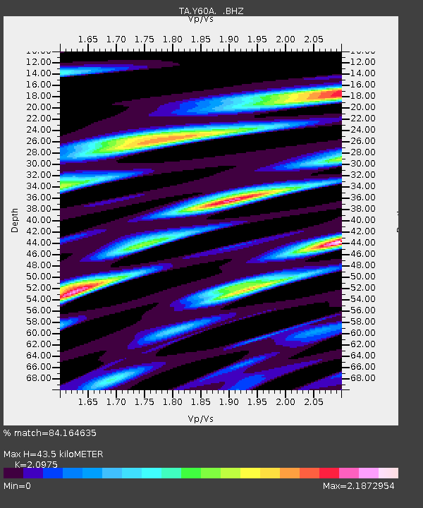
| Estimated Moho Depth: |
43.5 km |
| Estimated Crust Vp/Vs: |
2.10 |
| Assumed Crust Vp: |
6.565 km/s |
| Estimated Crust Vs: |
3.13 km/s |
| Estimated Crust Poisson's Ratio: |
0.35 |
|
| Radial Match: |
84.164635 % |
| Radial Bump: |
400 |
| Transverse Match: |
74.47565 % |
| Transverse Bump: |
400 |
| SOD ConfigId: |
626651 |
| Insert Time: |
2014-04-22 07:36:01.555 +0000 |
| GWidth: |
2.5 |
| Max Bumps: |
400 |
| Tol: |
0.001 |
|

Signal To Noise
| Channel | StoN | STA | LTA |
| TA:Y60A: :BHZ:20140403T05:35:14.374993Z | 1.905218 | 2.957098E-6 | 1.5521049E-6 |
| TA:Y60A: :BHN:20140403T05:35:14.374993Z | 1.7196451 | 3.0651554E-6 | 1.7824348E-6 |
| TA:Y60A: :BHE:20140403T05:35:14.374993Z | 1.2074901 | 1.2053091E-6 | 9.981939E-7 |
| Arrivals |
| Ps | 7.6 SECOND |
| PpPs | 20 SECOND |
| PsPs/PpSs | 27 SECOND |


