You are here: Home > Network List > US - United States National Seismic Network Stations List
> Station MNTX Cornudas Mountains, Texas, USA > Earthquake Result Viewer
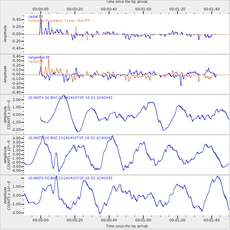
MNTX Cornudas Mountains, Texas, USA - Earthquake Result Viewer
*The percent match for this event was below the threshold and hence no stack was calculated.
| Earthquake location: |
Near Coast Of Northern Chile |
| Earthquake latitude/longitude: |
-20.8/-70.5 |
| Earthquake time(UTC): |
2014/04/03 (093) 05:26:16 GMT |
| Earthquake Depth: |
24 km |
| Earthquake Magnitude: |
6.2 MWP, 6.2 MWR, 6.3 MWW, 6.5 MWC |
| Earthquake Catalog/Contributor: |
NEIC PDE/NEIC COMCAT |
|
| Network: |
US United States National Seismic Network |
| Station: |
MNTX Cornudas Mountains, Texas, USA |
| Lat/Lon: |
31.70 N/105.38 W |
| Elevation: |
404 m |
|
| Distance: |
62.0 deg |
| Az: |
326.524 deg |
| Baz: |
142.742 deg |
| Ray Param: |
$rayparam |
*The percent match for this event was below the threshold and hence was not used in the summary stack. |
|
| Radial Match: |
79.03738 % |
| Radial Bump: |
400 |
| Transverse Match: |
50.56197 % |
| Transverse Bump: |
400 |
| SOD ConfigId: |
626651 |
| Insert Time: |
2014-04-22 07:38:21.450 +0000 |
| GWidth: |
2.5 |
| Max Bumps: |
400 |
| Tol: |
0.001 |
|
Signal To Noise
| Channel | StoN | STA | LTA |
| US:MNTX:00:BHZ:20140403T05:36:02.924004Z | 2.658425 | 3.428747E-6 | 1.2897663E-6 |
| US:MNTX:00:BH1:20140403T05:36:02.924004Z | 1.3795091 | 8.601198E-7 | 6.2349704E-7 |
| US:MNTX:00:BH2:20140403T05:36:02.924004Z | 0.43914917 | 6.666763E-7 | 1.518109E-6 |
| Arrivals |
| Ps | |
| PpPs | |
| PsPs/PpSs | |


