You are here: Home > Network List > AK - Alaska Regional Network Stations List
> Station GAMB Gambell Broadband > Earthquake Result Viewer
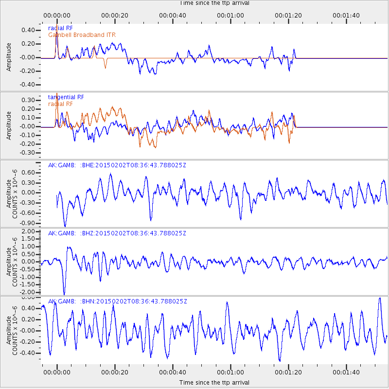
GAMB Gambell Broadband - Earthquake Result Viewer
*The percent match for this event was below the threshold and hence no stack was calculated.
| Earthquake location: |
Admiralty Islands Region, P.N.G. |
| Earthquake latitude/longitude: |
-1.6/145.2 |
| Earthquake time(UTC): |
2015/02/02 (033) 08:25:48 GMT |
| Earthquake Depth: |
10 km |
| Earthquake Magnitude: |
5.9 MB |
| Earthquake Catalog/Contributor: |
NEIC PDE/NEIC COMCAT |
|
| Network: |
AK Alaska Regional Network |
| Station: |
GAMB Gambell Broadband |
| Lat/Lon: |
63.78 N/171.70 W |
| Elevation: |
10 m |
|
| Distance: |
72.5 deg |
| Az: |
18.553 deg |
| Baz: |
225.721 deg |
| Ray Param: |
$rayparam |
*The percent match for this event was below the threshold and hence was not used in the summary stack. |
|
| Radial Match: |
41.760147 % |
| Radial Bump: |
400 |
| Transverse Match: |
38.676636 % |
| Transverse Bump: |
400 |
| SOD ConfigId: |
6977071 |
| Insert Time: |
2019-04-16 10:30:08.796 +0000 |
| GWidth: |
2.5 |
| Max Bumps: |
400 |
| Tol: |
0.001 |
|
Signal To Noise
| Channel | StoN | STA | LTA |
| AK:GAMB: :BHZ:20150202T08:36:43.788025Z | 4.3406105 | 8.802169E-7 | 2.0278644E-7 |
| AK:GAMB: :BHN:20150202T08:36:43.788025Z | 1.2450199 | 3.7263183E-7 | 2.992979E-7 |
| AK:GAMB: :BHE:20150202T08:36:43.788025Z | 1.0891856 | 3.476801E-7 | 3.192111E-7 |
| Arrivals |
| Ps | |
| PpPs | |
| PsPs/PpSs | |


