You are here: Home > Network List > TA - USArray Transportable Network (new EarthScope stations) Stations List
> Station T59A Double 'B' Farms, VA, USA > Earthquake Result Viewer
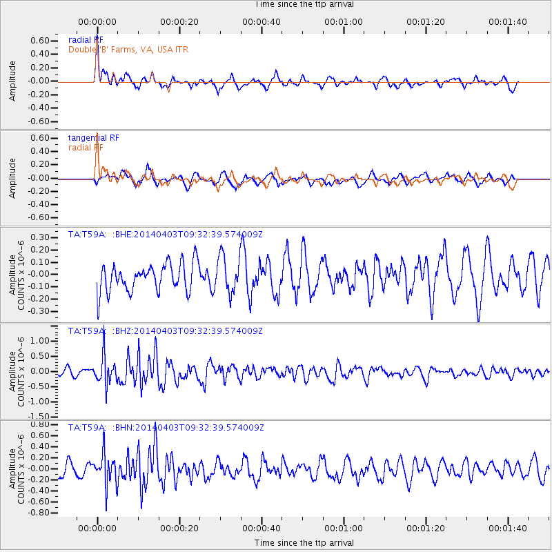
T59A Double 'B' Farms, VA, USA - Earthquake Result Viewer
*The percent match for this event was below the threshold and hence no stack was calculated.
| Earthquake location: |
Near Coast Of Northern Chile |
| Earthquake latitude/longitude: |
-20.6/-70.7 |
| Earthquake time(UTC): |
2014/04/03 (093) 09:23:21 GMT |
| Earthquake Depth: |
15 km |
| Earthquake Magnitude: |
5.6 MB, 5.3 MWR |
| Earthquake Catalog/Contributor: |
NEIC PDE/NEIC COMCAT |
|
| Network: |
TA USArray Transportable Network (new EarthScope stations) |
| Station: |
T59A Double 'B' Farms, VA, USA |
| Lat/Lon: |
36.97 N/77.55 W |
| Elevation: |
63 m |
|
| Distance: |
57.6 deg |
| Az: |
353.506 deg |
| Baz: |
172.395 deg |
| Ray Param: |
$rayparam |
*The percent match for this event was below the threshold and hence was not used in the summary stack. |
|
| Radial Match: |
71.22737 % |
| Radial Bump: |
400 |
| Transverse Match: |
67.928276 % |
| Transverse Bump: |
400 |
| SOD ConfigId: |
626651 |
| Insert Time: |
2014-04-22 09:12:55.228 +0000 |
| GWidth: |
2.5 |
| Max Bumps: |
400 |
| Tol: |
0.001 |
|
Signal To Noise
| Channel | StoN | STA | LTA |
| TA:T59A: :BHZ:20140403T09:32:39.574009Z | 2.9376435 | 4.7483735E-7 | 1.6163887E-7 |
| TA:T59A: :BHN:20140403T09:32:39.574009Z | 2.8861659 | 2.823244E-7 | 9.781988E-8 |
| TA:T59A: :BHE:20140403T09:32:39.574009Z | 1.3337594 | 1.5174376E-7 | 1.13771456E-7 |
| Arrivals |
| Ps | |
| PpPs | |
| PsPs/PpSs | |


