You are here: Home > Network List > TA - USArray Transportable Network (new EarthScope stations) Stations List
> Station Y57A Sumter, SC, USA > Earthquake Result Viewer
Y57A Sumter, SC, USA - Earthquake Result Viewer
*The percent match for this event was below the threshold and hence no stack was calculated.
| Earthquake location: |
Near Coast Of Northern Chile |
| Earthquake latitude/longitude: |
-20.6/-70.7 |
| Earthquake time(UTC): |
2014/04/03 (093) 09:23:21 GMT |
| Earthquake Depth: |
15 km |
| Earthquake Magnitude: |
5.6 MB, 5.3 MWR |
| Earthquake Catalog/Contributor: |
NEIC PDE/NEIC COMCAT |
|
| Network: |
TA USArray Transportable Network (new EarthScope stations) |
| Station: |
Y57A Sumter, SC, USA |
| Lat/Lon: |
34.02 N/80.39 W |
| Elevation: |
56 m |
|
| Distance: |
55.0 deg |
| Az: |
350.185 deg |
| Baz: |
168.912 deg |
| Ray Param: |
$rayparam |
*The percent match for this event was below the threshold and hence was not used in the summary stack. |
|
| Radial Match: |
64.846954 % |
| Radial Bump: |
400 |
| Transverse Match: |
70.83905 % |
| Transverse Bump: |
400 |
| SOD ConfigId: |
626651 |
| Insert Time: |
2014-04-22 09:14:25.889 +0000 |
| GWidth: |
2.5 |
| Max Bumps: |
400 |
| Tol: |
0.001 |
|
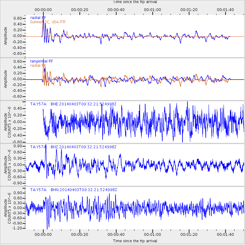
Signal To Noise
| Channel | StoN | STA | LTA |
| TA:Y57A: :BHZ:20140403T09:32:21.524998Z | 2.6082554 | 3.1696607E-7 | 1.2152417E-7 |
| TA:Y57A: :BHN:20140403T09:32:21.524998Z | 2.898252 | 4.9333414E-7 | 1.7021782E-7 |
| TA:Y57A: :BHE:20140403T09:32:21.524998Z | 1.2666202 | 2.1456313E-7 | 1.6939818E-7 |
| Arrivals |
| Ps | |
| PpPs | |
| PsPs/PpSs | |


