You are here: Home > Network List > TA - USArray Transportable Network (new EarthScope stations) Stations List
> Station Z41A Richland Creek Farm, El Dorado, AR, USA > Earthquake Result Viewer
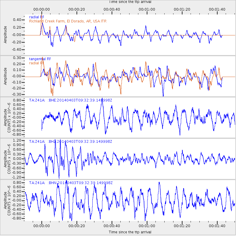
Z41A Richland Creek Farm, El Dorado, AR, USA - Earthquake Result Viewer
*The percent match for this event was below the threshold and hence no stack was calculated.
| Earthquake location: |
Near Coast Of Northern Chile |
| Earthquake latitude/longitude: |
-20.6/-70.7 |
| Earthquake time(UTC): |
2014/04/03 (093) 09:23:21 GMT |
| Earthquake Depth: |
15 km |
| Earthquake Magnitude: |
5.6 MB, 5.3 MWR |
| Earthquake Catalog/Contributor: |
NEIC PDE/NEIC COMCAT |
|
| Network: |
TA USArray Transportable Network (new EarthScope stations) |
| Station: |
Z41A Richland Creek Farm, El Dorado, AR, USA |
| Lat/Lon: |
33.26 N/92.80 W |
| Elevation: |
62 m |
|
| Distance: |
57.5 deg |
| Az: |
338.062 deg |
| Baz: |
155.302 deg |
| Ray Param: |
$rayparam |
*The percent match for this event was below the threshold and hence was not used in the summary stack. |
|
| Radial Match: |
43.0437 % |
| Radial Bump: |
400 |
| Transverse Match: |
44.585583 % |
| Transverse Bump: |
400 |
| SOD ConfigId: |
626651 |
| Insert Time: |
2014-04-22 09:14:36.741 +0000 |
| GWidth: |
2.5 |
| Max Bumps: |
400 |
| Tol: |
0.001 |
|
Signal To Noise
| Channel | StoN | STA | LTA |
| TA:Z41A: :BHZ:20140403T09:32:39.149998Z | 3.0181193 | 4.485142E-7 | 1.4860717E-7 |
| TA:Z41A: :BHN:20140403T09:32:39.149998Z | 0.47829705 | 2.1100838E-7 | 4.4116598E-7 |
| TA:Z41A: :BHE:20140403T09:32:39.149998Z | 1.62326 | 4.100588E-7 | 2.5261437E-7 |
| Arrivals |
| Ps | |
| PpPs | |
| PsPs/PpSs | |


