You are here: Home > Network List > AZ - ANZA Regional Network Stations List
> Station LVA2 AZ.LVA2 > Earthquake Result Viewer
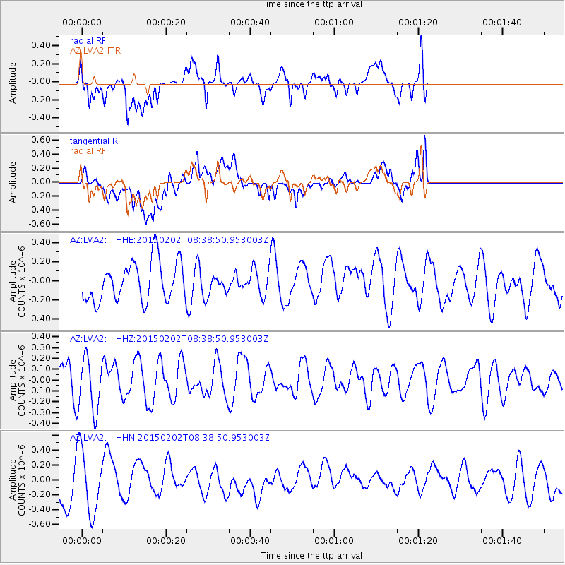
LVA2 AZ.LVA2 - Earthquake Result Viewer
*The percent match for this event was below the threshold and hence no stack was calculated.
| Earthquake location: |
Admiralty Islands Region, P.N.G. |
| Earthquake latitude/longitude: |
-1.6/145.2 |
| Earthquake time(UTC): |
2015/02/02 (033) 08:25:48 GMT |
| Earthquake Depth: |
10 km |
| Earthquake Magnitude: |
5.9 MB |
| Earthquake Catalog/Contributor: |
NEIC PDE/NEIC COMCAT |
|
| Network: |
AZ ANZA Regional Network |
| Station: |
LVA2 AZ.LVA2 |
| Lat/Lon: |
33.35 N/116.56 W |
| Elevation: |
1435 m |
|
| Distance: |
97.7 deg |
| Az: |
56.718 deg |
| Baz: |
273.229 deg |
| Ray Param: |
$rayparam |
*The percent match for this event was below the threshold and hence was not used in the summary stack. |
|
| Radial Match: |
67.86501 % |
| Radial Bump: |
400 |
| Transverse Match: |
48.70057 % |
| Transverse Bump: |
400 |
| SOD ConfigId: |
6977071 |
| Insert Time: |
2019-04-16 10:31:14.830 +0000 |
| GWidth: |
2.5 |
| Max Bumps: |
400 |
| Tol: |
0.001 |
|
Signal To Noise
| Channel | StoN | STA | LTA |
| AZ:LVA2: :HHZ:20150202T08:38:50.953003Z | 1.2242002 | 2.4029904E-7 | 1.9629063E-7 |
| AZ:LVA2: :HHN:20150202T08:38:50.953003Z | 1.9549567 | 4.3269213E-7 | 2.2133081E-7 |
| AZ:LVA2: :HHE:20150202T08:38:50.953003Z | 0.45673695 | 9.5836604E-8 | 2.0982888E-7 |
| Arrivals |
| Ps | |
| PpPs | |
| PsPs/PpSs | |


