You are here: Home > Network List > PF - Volcanologic Network of Piton de Fournaise-OVPF Stations List
> Station FRE Station Sismologique des Fonds de la Riviere de l'Est > Earthquake Result Viewer
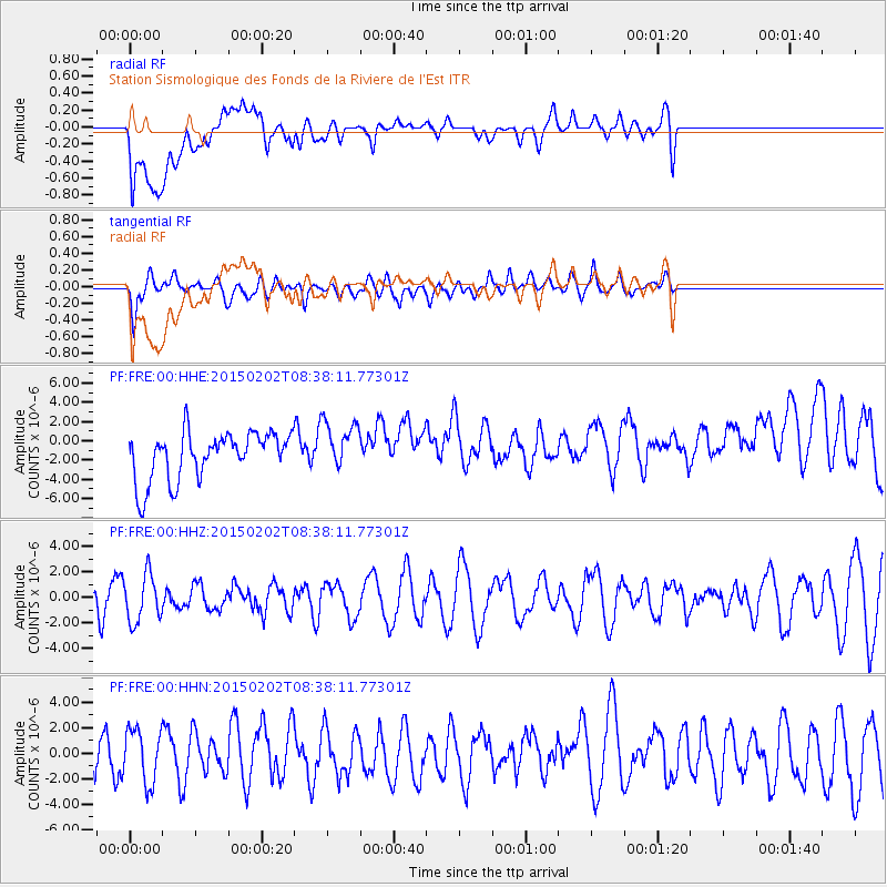
FRE Station Sismologique des Fonds de la Riviere de l'Est - Earthquake Result Viewer
*The percent match for this event was below the threshold and hence no stack was calculated.
| Earthquake location: |
Admiralty Islands Region, P.N.G. |
| Earthquake latitude/longitude: |
-1.6/145.2 |
| Earthquake time(UTC): |
2015/02/02 (033) 08:25:48 GMT |
| Earthquake Depth: |
10 km |
| Earthquake Magnitude: |
5.9 MB |
| Earthquake Catalog/Contributor: |
NEIC PDE/NEIC COMCAT |
|
| Network: |
PF Volcanologic Network of Piton de Fournaise-OVPF |
| Station: |
FRE Station Sismologique des Fonds de la Riviere de l'Est |
| Lat/Lon: |
21.20 S/55.70 E |
| Elevation: |
1775 m |
|
| Distance: |
89.0 deg |
| Az: |
248.945 deg |
| Baz: |
91.262 deg |
| Ray Param: |
$rayparam |
*The percent match for this event was below the threshold and hence was not used in the summary stack. |
|
| Radial Match: |
38.220013 % |
| Radial Bump: |
400 |
| Transverse Match: |
48.229225 % |
| Transverse Bump: |
400 |
| SOD ConfigId: |
6977071 |
| Insert Time: |
2019-04-16 10:36:32.301 +0000 |
| GWidth: |
2.5 |
| Max Bumps: |
400 |
| Tol: |
0.001 |
|
Signal To Noise
| Channel | StoN | STA | LTA |
| PF:FRE:00:HHZ:20150202T08:38:11.77301Z | 1.5049183 | 1.8480566E-6 | 1.2280112E-6 |
| PF:FRE:00:HHN:20150202T08:38:11.77301Z | 1.4938853 | 2.1098197E-6 | 1.4123036E-6 |
| PF:FRE:00:HHE:20150202T08:38:11.77301Z | 1.069584 | 2.6555476E-6 | 2.4827852E-6 |
| Arrivals |
| Ps | |
| PpPs | |
| PsPs/PpSs | |


