You are here: Home > Network List > TJ - Tajikistan National Seismic Network Stations List
> Station GARM Garm, Tajikistan > Earthquake Result Viewer
GARM Garm, Tajikistan - Earthquake Result Viewer
| Earthquake location: |
Admiralty Islands Region, P.N.G. |
| Earthquake latitude/longitude: |
-1.6/145.2 |
| Earthquake time(UTC): |
2015/02/02 (033) 08:25:48 GMT |
| Earthquake Depth: |
10 km |
| Earthquake Magnitude: |
5.9 MB |
| Earthquake Catalog/Contributor: |
NEIC PDE/NEIC COMCAT |
|
| Network: |
TJ Tajikistan National Seismic Network |
| Station: |
GARM Garm, Tajikistan |
| Lat/Lon: |
39.00 N/70.32 E |
| Elevation: |
1305 m |
|
| Distance: |
79.3 deg |
| Az: |
310.034 deg |
| Baz: |
100.809 deg |
| Ray Param: |
0.049075752 |
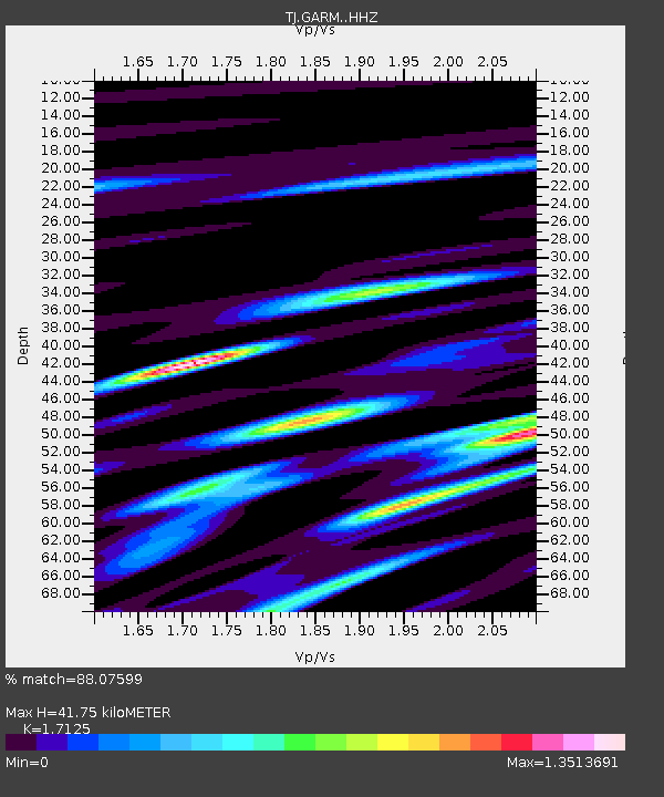
| Estimated Moho Depth: |
41.75 km |
| Estimated Crust Vp/Vs: |
1.71 |
| Assumed Crust Vp: |
6.306 km/s |
| Estimated Crust Vs: |
3.682 km/s |
| Estimated Crust Poisson's Ratio: |
0.24 |
|
| Radial Match: |
88.07599 % |
| Radial Bump: |
400 |
| Transverse Match: |
75.049706 % |
| Transverse Bump: |
400 |
| SOD ConfigId: |
6977071 |
| Insert Time: |
2019-04-16 10:38:25.689 +0000 |
| GWidth: |
2.5 |
| Max Bumps: |
400 |
| Tol: |
0.001 |
|
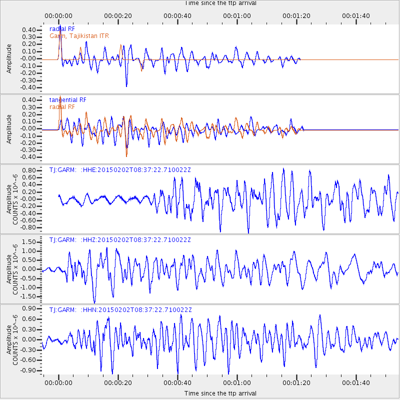
Signal To Noise
| Channel | StoN | STA | LTA |
| TJ:GARM: :HHZ:20150202T08:37:22.710022Z | 2.8506775 | 3.5787258E-7 | 1.2553949E-7 |
| TJ:GARM: :HHN:20150202T08:37:22.710022Z | 0.49559918 | 8.8528566E-8 | 1.7862935E-7 |
| TJ:GARM: :HHE:20150202T08:37:22.710022Z | 1.696343 | 1.3705535E-7 | 8.079461E-8 |
| Arrivals |
| Ps | 4.9 SECOND |
| PpPs | 17 SECOND |
| PsPs/PpSs | 22 SECOND |


