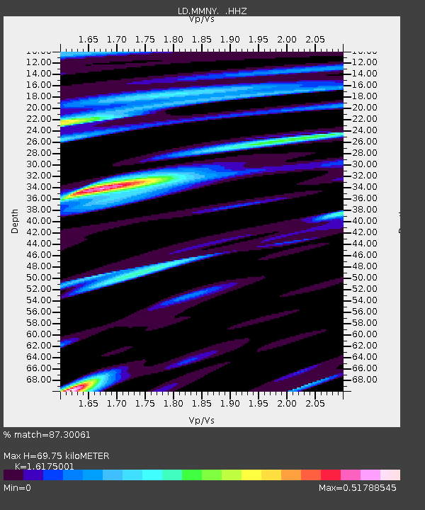
MMNY Mount Morris Dam, NY - Earthquake Result Viewer

Earthquake location: Near Coast Of Northern Chile
Earthquake latitude/longitude: -20.6/-70.7
Earthquake time(UTC): 2014/04/04 (094) 01:37:51 GMT
Earthquake Depth: 20 km
Earthquake Magnitude: 6.1 MWP, 6.1 MWB, 6.1 MWW, 6.3 MWC
Earthquake Catalog/Contributor: NEIC PDE/NEIC COMCAT
Network: LD Lamont-Doherty Cooperative Seismographic Network
Station: MMNY Mount Morris Dam, NY
Lat/Lon: 42.73 N/77.91 W
Elevation: 241 m
Distance: 63.4 deg
Az: 354.098 deg
Baz: 172.488 deg
Ray Param: 0.059592262
Estimated Moho Depth: 69.75 km
Estimated Crust Vp/Vs: 1.62
Assumed Crust Vp: 6.476 km/s
Estimated Crust Vs: 4.004 km/s
Estimated Crust Poisson's Ratio: 0.19
Radial Match: 87.30061 %
Radial Bump: 301
Transverse Match: 54.32473 %
Transverse Bump: 400
SOD ConfigId: 626651
Insert Time: 2014-04-22 09:40:23.202 +0000
GWidth: 2.5
Max Bumps: 400
Tol: 0.001

Signal To Noise

ChannelStoNSTALTA
LD:MMNY: :HHZ:20140404T01:47:47.939998Z3.92360472.1522615E-65.4854183E-7
LD:MMNY: :HHN:20140404T01:47:47.939998Z3.50370299.443142E-72.6951892E-7
LD:MMNY: :HHE:20140404T01:47:47.939998Z0.88054442.0685894E-72.3492166E-7
Arrivals
Ps7.0 SECOND
PpPs27 SECOND
PsPs/PpSs34 SECOND