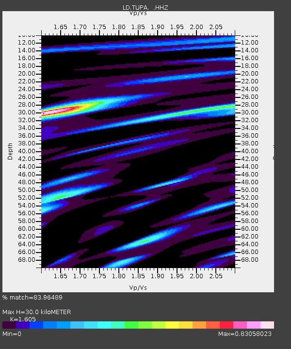
TUPA Temple University, Pennsylvania - Earthquake Result Viewer
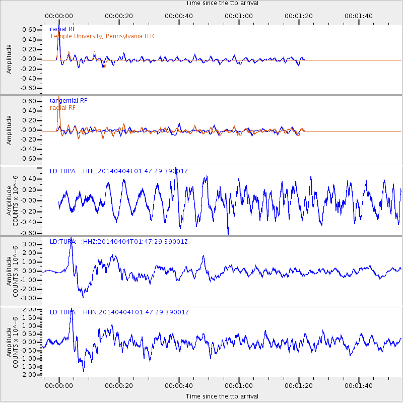
Earthquake location: Near Coast Of Northern Chile
Earthquake latitude/longitude: -20.6/-70.7
Earthquake time(UTC): 2014/04/04 (094) 01:37:51 GMT
Earthquake Depth: 20 km
Earthquake Magnitude: 6.1 MWP, 6.1 MWB, 6.1 MWW, 6.3 MWC
Earthquake Catalog/Contributor: NEIC PDE/NEIC COMCAT
Network: LD Lamont-Doherty Cooperative Seismographic Network
Station: TUPA Temple University, Pennsylvania
Lat/Lon: 40.17 N/75.19 W
Elevation: 112 m
Distance: 60.6 deg
Az: 356.09 deg
Baz: 175.218 deg
Ray Param: 0.06139349
Estimated Moho Depth: 30.0 km
Estimated Crust Vp/Vs: 1.61
Assumed Crust Vp: 6.283 km/s
Estimated Crust Vs: 3.915 km/s
Estimated Crust Poisson's Ratio: 0.18
Radial Match: 83.96489 %
Radial Bump: 400
Transverse Match: 39.2885 %
Transverse Bump: 400
SOD ConfigId: 626651
Insert Time: 2014-04-22 09:40:47.399 +0000
GWidth: 2.5
Max Bumps: 400
Tol: 0.001

Signal To Noise

ChannelStoNSTALTA
LD:TUPA: :HHZ:20140404T01:47:29.39001Z8.5945391.3593475E-61.581641E-7
LD:TUPA: :HHN:20140404T01:47:29.39001Z6.6440817.6454137E-71.15071046E-7
LD:TUPA: :HHE:20140404T01:47:29.39001Z1.15996311.896341E-71.6348285E-7
Arrivals
Ps3.0 SECOND
PpPs12 SECOND
PsPs/PpSs15 SECOND