You are here: Home > Network List > N4 - Central and EAstern US Network Stations List
> Station W50A Signal Mountain, TN, USA > Earthquake Result Viewer
W50A Signal Mountain, TN, USA - Earthquake Result Viewer
| Earthquake location: |
Near Coast Of Northern Chile |
| Earthquake latitude/longitude: |
-20.6/-70.7 |
| Earthquake time(UTC): |
2014/04/04 (094) 01:37:51 GMT |
| Earthquake Depth: |
20 km |
| Earthquake Magnitude: |
6.1 MWP, 6.1 MWB, 6.1 MWW, 6.3 MWC |
| Earthquake Catalog/Contributor: |
NEIC PDE/NEIC COMCAT |
|
| Network: |
N4 Central and EAstern US Network |
| Station: |
W50A Signal Mountain, TN, USA |
| Lat/Lon: |
35.20 N/85.31 W |
| Elevation: |
587 m |
|
| Distance: |
57.2 deg |
| Az: |
345.812 deg |
| Baz: |
163.719 deg |
| Ray Param: |
0.06361156 |
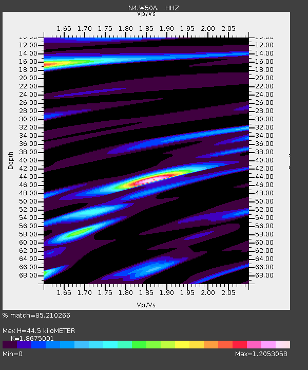
| Estimated Moho Depth: |
44.5 km |
| Estimated Crust Vp/Vs: |
1.87 |
| Assumed Crust Vp: |
6.35 km/s |
| Estimated Crust Vs: |
3.4 km/s |
| Estimated Crust Poisson's Ratio: |
0.30 |
|
| Radial Match: |
85.210266 % |
| Radial Bump: |
384 |
| Transverse Match: |
58.006195 % |
| Transverse Bump: |
400 |
| SOD ConfigId: |
626651 |
| Insert Time: |
2014-04-22 09:44:20.925 +0000 |
| GWidth: |
2.5 |
| Max Bumps: |
400 |
| Tol: |
0.001 |
|

Signal To Noise
| Channel | StoN | STA | LTA |
| N4:W50A: :HHZ:20140404T01:47:05.830012Z | 8.035281 | 1.4867144E-6 | 1.8502332E-7 |
| N4:W50A: :HHN:20140404T01:47:05.830012Z | 5.8200326 | 6.5241267E-7 | 1.12097766E-7 |
| N4:W50A: :HHE:20140404T01:47:05.830012Z | 1.0053159 | 1.5663835E-7 | 1.5581007E-7 |
| Arrivals |
| Ps | 6.4 SECOND |
| PpPs | 19 SECOND |
| PsPs/PpSs | 26 SECOND |


