You are here: Home > Network List > TA - USArray Transportable Network (new EarthScope stations) Stations List
> Station D46A Sault St. Marie, ON, CAN > Earthquake Result Viewer
D46A Sault St. Marie, ON, CAN - Earthquake Result Viewer
| Earthquake location: |
Near Coast Of Northern Chile |
| Earthquake latitude/longitude: |
-20.6/-70.7 |
| Earthquake time(UTC): |
2014/04/04 (094) 01:37:51 GMT |
| Earthquake Depth: |
20 km |
| Earthquake Magnitude: |
6.1 MWP, 6.1 MWB, 6.1 MWW, 6.3 MWC |
| Earthquake Catalog/Contributor: |
NEIC PDE/NEIC COMCAT |
|
| Network: |
TA USArray Transportable Network (new EarthScope stations) |
| Station: |
D46A Sault St. Marie, ON, CAN |
| Lat/Lon: |
46.89 N/84.04 W |
| Elevation: |
353 m |
|
| Distance: |
68.3 deg |
| Az: |
350.223 deg |
| Baz: |
166.589 deg |
| Ray Param: |
0.056399763 |
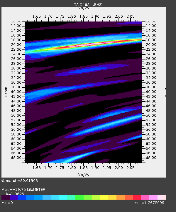
| Estimated Moho Depth: |
19.75 km |
| Estimated Crust Vp/Vs: |
1.86 |
| Assumed Crust Vp: |
6.467 km/s |
| Estimated Crust Vs: |
3.472 km/s |
| Estimated Crust Poisson's Ratio: |
0.30 |
|
| Radial Match: |
80.01508 % |
| Radial Bump: |
400 |
| Transverse Match: |
65.06454 % |
| Transverse Bump: |
400 |
| SOD ConfigId: |
626651 |
| Insert Time: |
2014-04-22 09:51:02.238 +0000 |
| GWidth: |
2.5 |
| Max Bumps: |
400 |
| Tol: |
0.001 |
|
Signal To Noise
| Channel | StoN | STA | LTA |
| TA:D46A: :BHZ:20140404T01:48:19.299983Z | 6.41103 | 1.0036615E-6 | 1.565523E-7 |
| TA:D46A: :BHN:20140404T01:48:19.299983Z | 4.705752 | 5.4055886E-7 | 1.14871945E-7 |
| TA:D46A: :BHE:20140404T01:48:19.299983Z | 1.1044149 | 1.833019E-7 | 1.6597195E-7 |
| Arrivals |
| Ps | 2.7 SECOND |
| PpPs | 8.4 SECOND |
| PsPs/PpSs | 11 SECOND |


