You are here: Home > Network List > CI - Caltech Regional Seismic Network Stations List
> Station BFS Mt Baldy Forest Station > Earthquake Result Viewer
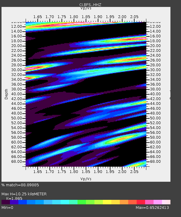
BFS Mt Baldy Forest Station - Earthquake Result Viewer
| Earthquake location: |
Mendoza Province, Argentina |
| Earthquake latitude/longitude: |
-32.7/-67.1 |
| Earthquake time(UTC): |
2015/02/02 (033) 10:49:48 GMT |
| Earthquake Depth: |
172 km |
| Earthquake Magnitude: |
6.3 MO |
| Earthquake Catalog/Contributor: |
NEIC PDE/NEIC ALERT |
|
| Network: |
CI Caltech Regional Seismic Network |
| Station: |
BFS Mt Baldy Forest Station |
| Lat/Lon: |
34.24 N/117.66 W |
| Elevation: |
1312 m |
|
| Distance: |
81.8 deg |
| Az: |
319.706 deg |
| Baz: |
138.847 deg |
| Ray Param: |
0.04689648 |
| Estimated Moho Depth: |
10.25 km |
| Estimated Crust Vp/Vs: |
1.87 |
| Assumed Crust Vp: |
6.276 km/s |
| Estimated Crust Vs: |
3.365 km/s |
| Estimated Crust Poisson's Ratio: |
0.30 |
|
| Radial Match: |
88.89885 % |
| Radial Bump: |
400 |
| Transverse Match: |
77.47733 % |
| Transverse Bump: |
400 |
| SOD ConfigId: |
6977071 |
| Insert Time: |
2019-04-16 10:51:11.672 +0000 |
| GWidth: |
2.5 |
| Max Bumps: |
400 |
| Tol: |
0.001 |
|

Signal To Noise
| Channel | StoN | STA | LTA |
| CI:BFS: :HHZ:20150202T11:01:16.577991Z | 10.342719 | 1.9652516E-6 | 1.9001305E-7 |
| CI:BFS: :HHN:20150202T11:01:16.577991Z | 5.715741 | 5.386206E-7 | 9.423461E-8 |
| CI:BFS: :HHE:20150202T11:01:16.577991Z | 4.675025 | 5.7526415E-7 | 1.2305051E-7 |
| Arrivals |
| Ps | 1.4 SECOND |
| PpPs | 4.6 SECOND |
| PsPs/PpSs | 6.0 SECOND |


