You are here: Home > Network List > TA - USArray Transportable Network (new EarthScope stations) Stations List
> Station D57A Chemin Vers le Barrage, Saint-Michel-Des-Saints, Q > Earthquake Result Viewer
D57A Chemin Vers le Barrage, Saint-Michel-Des-Saints, Q - Earthquake Result Viewer
| Earthquake location: |
Near Coast Of Northern Chile |
| Earthquake latitude/longitude: |
-20.6/-70.7 |
| Earthquake time(UTC): |
2014/04/04 (094) 01:37:51 GMT |
| Earthquake Depth: |
20 km |
| Earthquake Magnitude: |
6.1 MWP, 6.1 MWB, 6.1 MWW, 6.3 MWC |
| Earthquake Catalog/Contributor: |
NEIC PDE/NEIC COMCAT |
|
| Network: |
TA USArray Transportable Network (new EarthScope stations) |
| Station: |
D57A Chemin Vers le Barrage, Saint-Michel-Des-Saints, Q |
| Lat/Lon: |
47.02 N/73.89 W |
| Elevation: |
422 m |
|
| Distance: |
67.4 deg |
| Az: |
357.667 deg |
| Baz: |
176.805 deg |
| Ray Param: |
0.05697352 |
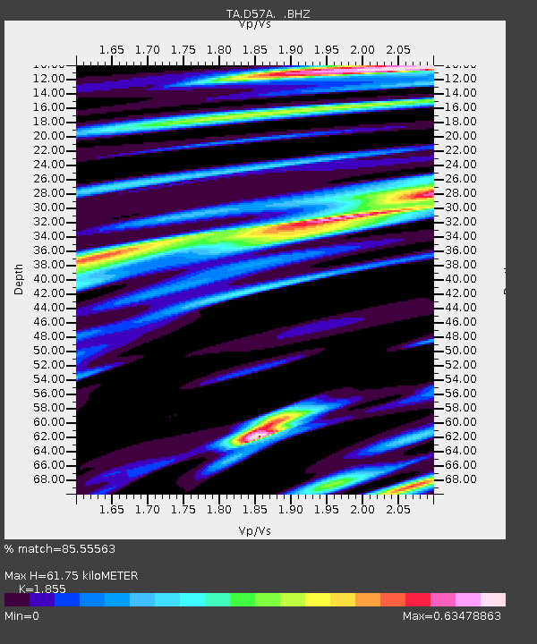
| Estimated Moho Depth: |
61.75 km |
| Estimated Crust Vp/Vs: |
1.86 |
| Assumed Crust Vp: |
6.61 km/s |
| Estimated Crust Vs: |
3.563 km/s |
| Estimated Crust Poisson's Ratio: |
0.30 |
|
| Radial Match: |
85.55563 % |
| Radial Bump: |
400 |
| Transverse Match: |
73.43917 % |
| Transverse Bump: |
400 |
| SOD ConfigId: |
626651 |
| Insert Time: |
2014-04-22 09:51:26.127 +0000 |
| GWidth: |
2.5 |
| Max Bumps: |
400 |
| Tol: |
0.001 |
|

Signal To Noise
| Channel | StoN | STA | LTA |
| TA:D57A: :BHZ:20140404T01:48:13.77502Z | 8.572433 | 1.7790687E-6 | 2.0753367E-7 |
| TA:D57A: :BHN:20140404T01:48:13.77502Z | 5.5549297 | 8.7730274E-7 | 1.5793228E-7 |
| TA:D57A: :BHE:20140404T01:48:13.77502Z | 1.4331199 | 1.8677966E-7 | 1.3033079E-7 |
| Arrivals |
| Ps | 8.3 SECOND |
| PpPs | 26 SECOND |
| PsPs/PpSs | 34 SECOND |


