You are here: Home > Network List > TA - USArray Transportable Network (new EarthScope stations) Stations List
> Station G60A Masonville, QC, CAN > Earthquake Result Viewer
G60A Masonville, QC, CAN - Earthquake Result Viewer
| Earthquake location: |
Near Coast Of Northern Chile |
| Earthquake latitude/longitude: |
-20.6/-70.7 |
| Earthquake time(UTC): |
2014/04/04 (094) 01:37:51 GMT |
| Earthquake Depth: |
20 km |
| Earthquake Magnitude: |
6.1 MWP, 6.1 MWB, 6.1 MWW, 6.3 MWC |
| Earthquake Catalog/Contributor: |
NEIC PDE/NEIC COMCAT |
|
| Network: |
TA USArray Transportable Network (new EarthScope stations) |
| Station: |
G60A Masonville, QC, CAN |
| Lat/Lon: |
45.10 N/72.33 W |
| Elevation: |
391 m |
|
| Distance: |
65.4 deg |
| Az: |
358.758 deg |
| Baz: |
178.358 deg |
| Ray Param: |
0.058264796 |
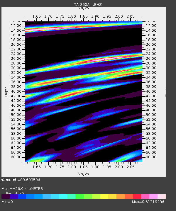
| Estimated Moho Depth: |
26.0 km |
| Estimated Crust Vp/Vs: |
1.94 |
| Assumed Crust Vp: |
6.419 km/s |
| Estimated Crust Vs: |
3.313 km/s |
| Estimated Crust Poisson's Ratio: |
0.32 |
|
| Radial Match: |
89.693596 % |
| Radial Bump: |
336 |
| Transverse Match: |
64.95404 % |
| Transverse Bump: |
400 |
| SOD ConfigId: |
626651 |
| Insert Time: |
2014-04-22 09:53:32.957 +0000 |
| GWidth: |
2.5 |
| Max Bumps: |
400 |
| Tol: |
0.001 |
|

Signal To Noise
| Channel | StoN | STA | LTA |
| TA:G60A: :BHZ:20140404T01:48:01.249995Z | 10.04061 | 1.8805091E-6 | 1.8729031E-7 |
| TA:G60A: :BHN:20140404T01:48:01.249995Z | 6.259663 | 1.0098856E-6 | 1.6133225E-7 |
| TA:G60A: :BHE:20140404T01:48:01.249995Z | 1.9595851 | 3.8293393E-7 | 1.9541584E-7 |
| Arrivals |
| Ps | 3.9 SECOND |
| PpPs | 11 SECOND |
| PsPs/PpSs | 15 SECOND |


