You are here: Home > Network List > TA - USArray Transportable Network (new EarthScope stations) Stations List
> Station G62A West of Eustis, ME, USA > Earthquake Result Viewer
G62A West of Eustis, ME, USA - Earthquake Result Viewer
| Earthquake location: |
Near Coast Of Northern Chile |
| Earthquake latitude/longitude: |
-20.6/-70.7 |
| Earthquake time(UTC): |
2014/04/04 (094) 01:37:51 GMT |
| Earthquake Depth: |
20 km |
| Earthquake Magnitude: |
6.1 MWP, 6.1 MWB, 6.1 MWW, 6.3 MWC |
| Earthquake Catalog/Contributor: |
NEIC PDE/NEIC COMCAT |
|
| Network: |
TA USArray Transportable Network (new EarthScope stations) |
| Station: |
G62A West of Eustis, ME, USA |
| Lat/Lon: |
45.22 N/70.53 W |
| Elevation: |
426 m |
|
| Distance: |
65.5 deg |
| Az: |
0.161 deg |
| Baz: |
180.213 deg |
| Ray Param: |
0.05819587 |
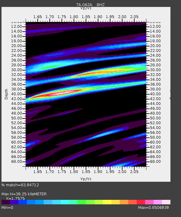
| Estimated Moho Depth: |
39.25 km |
| Estimated Crust Vp/Vs: |
1.76 |
| Assumed Crust Vp: |
6.419 km/s |
| Estimated Crust Vs: |
3.652 km/s |
| Estimated Crust Poisson's Ratio: |
0.26 |
|
| Radial Match: |
83.94712 % |
| Radial Bump: |
388 |
| Transverse Match: |
74.91924 % |
| Transverse Bump: |
400 |
| SOD ConfigId: |
626651 |
| Insert Time: |
2014-04-22 09:53:37.974 +0000 |
| GWidth: |
2.5 |
| Max Bumps: |
400 |
| Tol: |
0.001 |
|

Signal To Noise
| Channel | StoN | STA | LTA |
| TA:G62A: :BHZ:20140404T01:48:01.924983Z | 9.327609 | 1.9205258E-6 | 2.0589691E-7 |
| TA:G62A: :BHN:20140404T01:48:01.924983Z | 4.844921 | 8.739012E-7 | 1.803747E-7 |
| TA:G62A: :BHE:20140404T01:48:01.924983Z | 1.1365552 | 2.0462848E-7 | 1.8004272E-7 |
| Arrivals |
| Ps | 4.8 SECOND |
| PpPs | 16 SECOND |
| PsPs/PpSs | 21 SECOND |


