You are here: Home > Network List > CI - Caltech Regional Seismic Network Stations List
> Station SWS Sam W. Stewart, Westmorland, CA, USA > Earthquake Result Viewer
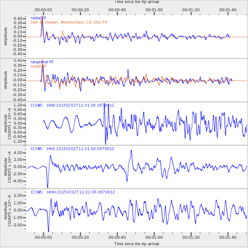
SWS Sam W. Stewart, Westmorland, CA, USA - Earthquake Result Viewer
*The percent match for this event was below the threshold and hence no stack was calculated.
| Earthquake location: |
Mendoza Province, Argentina |
| Earthquake latitude/longitude: |
-32.7/-67.1 |
| Earthquake time(UTC): |
2015/02/02 (033) 10:49:48 GMT |
| Earthquake Depth: |
172 km |
| Earthquake Magnitude: |
6.3 MO |
| Earthquake Catalog/Contributor: |
NEIC PDE/NEIC ALERT |
|
| Network: |
CI Caltech Regional Seismic Network |
| Station: |
SWS Sam W. Stewart, Westmorland, CA, USA |
| Lat/Lon: |
32.94 N/115.80 W |
| Elevation: |
140 m |
|
| Distance: |
79.8 deg |
| Az: |
320.048 deg |
| Baz: |
139.927 deg |
| Ray Param: |
$rayparam |
*The percent match for this event was below the threshold and hence was not used in the summary stack. |
|
| Radial Match: |
81.99888 % |
| Radial Bump: |
400 |
| Transverse Match: |
76.51231 % |
| Transverse Bump: |
400 |
| SOD ConfigId: |
6977071 |
| Insert Time: |
2019-04-16 10:52:38.356 +0000 |
| GWidth: |
2.5 |
| Max Bumps: |
400 |
| Tol: |
0.001 |
|
Signal To Noise
| Channel | StoN | STA | LTA |
| CI:SWS: :HHZ:20150202T11:01:06.067981Z | 11.294365 | 2.262914E-6 | 2.0035779E-7 |
| CI:SWS: :HHN:20150202T11:01:06.067981Z | 3.7429802 | 9.943911E-7 | 2.656683E-7 |
| CI:SWS: :HHE:20150202T11:01:06.067981Z | 2.4203393 | 6.4451984E-7 | 2.6629317E-7 |
| Arrivals |
| Ps | |
| PpPs | |
| PsPs/PpSs | |


