You are here: Home > Network List > TA - USArray Transportable Network (new EarthScope stations) Stations List
> Station I59A Olmsteadville, NY, USA > Earthquake Result Viewer
I59A Olmsteadville, NY, USA - Earthquake Result Viewer
| Earthquake location: |
Near Coast Of Northern Chile |
| Earthquake latitude/longitude: |
-20.6/-70.7 |
| Earthquake time(UTC): |
2014/04/04 (094) 01:37:51 GMT |
| Earthquake Depth: |
20 km |
| Earthquake Magnitude: |
6.1 MWP, 6.1 MWB, 6.1 MWW, 6.3 MWC |
| Earthquake Catalog/Contributor: |
NEIC PDE/NEIC COMCAT |
|
| Network: |
TA USArray Transportable Network (new EarthScope stations) |
| Station: |
I59A Olmsteadville, NY, USA |
| Lat/Lon: |
43.80 N/73.87 W |
| Elevation: |
390 m |
|
| Distance: |
64.2 deg |
| Az: |
357.478 deg |
| Baz: |
176.737 deg |
| Ray Param: |
0.05907832 |
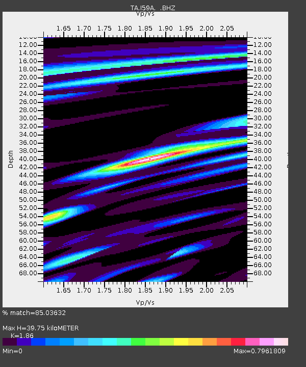
| Estimated Moho Depth: |
39.75 km |
| Estimated Crust Vp/Vs: |
1.86 |
| Assumed Crust Vp: |
6.419 km/s |
| Estimated Crust Vs: |
3.451 km/s |
| Estimated Crust Poisson's Ratio: |
0.30 |
|
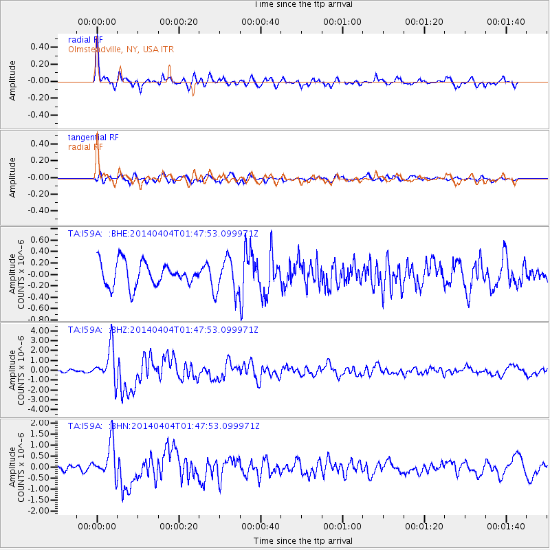
| Radial Match: |
85.03632 % |
| Radial Bump: |
377 |
| Transverse Match: |
50.840206 % |
| Transverse Bump: |
379 |
| SOD ConfigId: |
626651 |
| Insert Time: |
2014-04-22 09:55:19.675 +0000 |
| GWidth: |
2.5 |
| Max Bumps: |
400 |
| Tol: |
0.001 |
|
Signal To Noise
| Channel | StoN | STA | LTA |
| TA:I59A: :BHZ:20140404T01:47:53.099971Z | 6.3586307 | 1.8509519E-6 | 2.9109285E-7 |
| TA:I59A: :BHN:20140404T01:47:53.099971Z | 3.7409415 | 8.319371E-7 | 2.223871E-7 |
| TA:I59A: :BHE:20140404T01:47:53.099971Z | 1.4512943 | 3.004608E-7 | 2.0702956E-7 |
| Arrivals |
| Ps | 5.5 SECOND |
| PpPs | 17 SECOND |
| PsPs/PpSs | 23 SECOND |


