You are here: Home > Network List > TA - USArray Transportable Network (new EarthScope stations) Stations List
> Station I63A Otisfield, ME, USA > Earthquake Result Viewer
I63A Otisfield, ME, USA - Earthquake Result Viewer
| Earthquake location: |
Near Coast Of Northern Chile |
| Earthquake latitude/longitude: |
-20.6/-70.7 |
| Earthquake time(UTC): |
2014/04/04 (094) 01:37:51 GMT |
| Earthquake Depth: |
20 km |
| Earthquake Magnitude: |
6.1 MWP, 6.1 MWB, 6.1 MWW, 6.3 MWC |
| Earthquake Catalog/Contributor: |
NEIC PDE/NEIC COMCAT |
|
| Network: |
TA USArray Transportable Network (new EarthScope stations) |
| Station: |
I63A Otisfield, ME, USA |
| Lat/Lon: |
44.05 N/70.58 W |
| Elevation: |
177 m |
|
| Distance: |
64.4 deg |
| Az: |
0.127 deg |
| Baz: |
180.165 deg |
| Ray Param: |
0.058955133 |
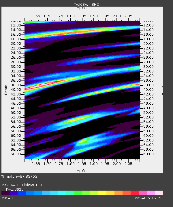
| Estimated Moho Depth: |
38.0 km |
| Estimated Crust Vp/Vs: |
1.66 |
| Assumed Crust Vp: |
6.419 km/s |
| Estimated Crust Vs: |
3.861 km/s |
| Estimated Crust Poisson's Ratio: |
0.22 |
|
| Radial Match: |
87.85705 % |
| Radial Bump: |
400 |
| Transverse Match: |
73.12082 % |
| Transverse Bump: |
400 |
| SOD ConfigId: |
626651 |
| Insert Time: |
2014-04-22 09:55:29.591 +0000 |
| GWidth: |
2.5 |
| Max Bumps: |
400 |
| Tol: |
0.001 |
|

Signal To Noise
| Channel | StoN | STA | LTA |
| TA:I63A: :BHZ:20140404T01:47:54.325007Z | 7.5745525 | 2.021687E-6 | 2.6690512E-7 |
| TA:I63A: :BHN:20140404T01:47:54.325007Z | 5.2225957 | 9.307952E-7 | 1.7822464E-7 |
| TA:I63A: :BHE:20140404T01:47:54.325007Z | 0.55233115 | 1.10207765E-7 | 1.9953205E-7 |
| Arrivals |
| Ps | 4.1 SECOND |
| PpPs | 15 SECOND |
| PsPs/PpSs | 19 SECOND |


