You are here: Home > Network List > TA - USArray Transportable Network (new EarthScope stations) Stations List
> Station L61B Northampton, MA, USA > Earthquake Result Viewer
L61B Northampton, MA, USA - Earthquake Result Viewer
| Earthquake location: |
Near Coast Of Northern Chile |
| Earthquake latitude/longitude: |
-20.6/-70.7 |
| Earthquake time(UTC): |
2014/04/04 (094) 01:37:51 GMT |
| Earthquake Depth: |
20 km |
| Earthquake Magnitude: |
6.1 MWP, 6.1 MWB, 6.1 MWW, 6.3 MWC |
| Earthquake Catalog/Contributor: |
NEIC PDE/NEIC COMCAT |
|
| Network: |
TA USArray Transportable Network (new EarthScope stations) |
| Station: |
L61B Northampton, MA, USA |
| Lat/Lon: |
42.45 N/72.68 W |
| Elevation: |
261 m |
|
| Distance: |
62.8 deg |
| Az: |
358.385 deg |
| Baz: |
177.955 deg |
| Ray Param: |
0.059982203 |
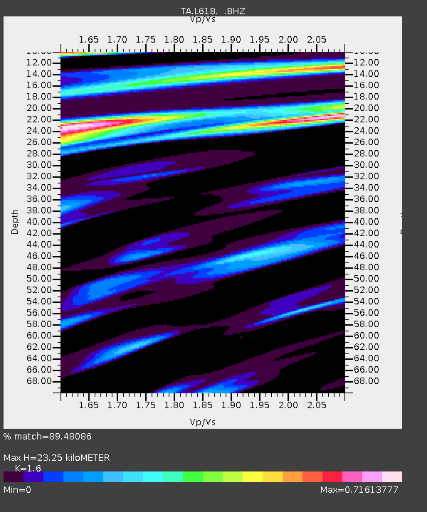
| Estimated Moho Depth: |
23.25 km |
| Estimated Crust Vp/Vs: |
1.60 |
| Assumed Crust Vp: |
6.419 km/s |
| Estimated Crust Vs: |
4.012 km/s |
| Estimated Crust Poisson's Ratio: |
0.18 |
|
| Radial Match: |
89.48086 % |
| Radial Bump: |
400 |
| Transverse Match: |
51.063637 % |
| Transverse Bump: |
400 |
| SOD ConfigId: |
626651 |
| Insert Time: |
2014-04-22 09:58:01.069 +0000 |
| GWidth: |
2.5 |
| Max Bumps: |
400 |
| Tol: |
0.001 |
|

Signal To Noise
| Channel | StoN | STA | LTA |
| TA:L61B: :BHZ:20140404T01:47:43.950007Z | 11.550024 | 1.7306979E-6 | 1.4984366E-7 |
| TA:L61B: :BHN:20140404T01:47:43.950007Z | 5.958646 | 8.497189E-7 | 1.4260269E-7 |
| TA:L61B: :BHE:20140404T01:47:43.950007Z | 0.9610884 | 1.7494371E-7 | 1.8202665E-7 |
| Arrivals |
| Ps | 2.3 SECOND |
| PpPs | 9.0 SECOND |
| PsPs/PpSs | 11 SECOND |


