You are here: Home > Network List > TA - USArray Transportable Network (new EarthScope stations) Stations List
> Station L63A North Scituate, RI, USA > Earthquake Result Viewer
L63A North Scituate, RI, USA - Earthquake Result Viewer
| Earthquake location: |
Near Coast Of Northern Chile |
| Earthquake latitude/longitude: |
-20.6/-70.7 |
| Earthquake time(UTC): |
2014/04/04 (094) 01:37:51 GMT |
| Earthquake Depth: |
20 km |
| Earthquake Magnitude: |
6.1 MWP, 6.1 MWB, 6.1 MWW, 6.3 MWC |
| Earthquake Catalog/Contributor: |
NEIC PDE/NEIC COMCAT |
|
| Network: |
TA USArray Transportable Network (new EarthScope stations) |
| Station: |
L63A North Scituate, RI, USA |
| Lat/Lon: |
41.86 N/71.61 W |
| Elevation: |
109 m |
|
| Distance: |
62.2 deg |
| Az: |
359.265 deg |
| Baz: |
179.078 deg |
| Ray Param: |
0.060379986 |
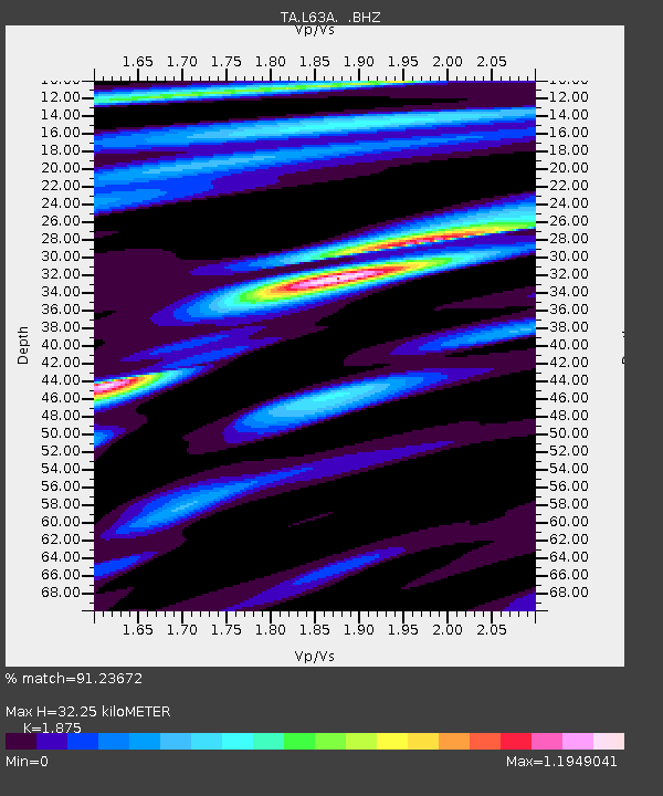
| Estimated Moho Depth: |
32.25 km |
| Estimated Crust Vp/Vs: |
1.88 |
| Assumed Crust Vp: |
6.472 km/s |
| Estimated Crust Vs: |
3.452 km/s |
| Estimated Crust Poisson's Ratio: |
0.30 |
|
| Radial Match: |
91.23672 % |
| Radial Bump: |
326 |
| Transverse Match: |
68.817 % |
| Transverse Bump: |
400 |
| SOD ConfigId: |
626651 |
| Insert Time: |
2014-04-22 09:58:06.610 +0000 |
| GWidth: |
2.5 |
| Max Bumps: |
400 |
| Tol: |
0.001 |
|

Signal To Noise
| Channel | StoN | STA | LTA |
| TA:L63A: :BHZ:20140404T01:47:39.90002Z | 10.807644 | 2.294764E-6 | 2.1232788E-7 |
| TA:L63A: :BHN:20140404T01:47:39.90002Z | 6.387786 | 1.1835996E-6 | 1.8529106E-7 |
| TA:L63A: :BHE:20140404T01:47:39.90002Z | 1.495334 | 2.7398164E-7 | 1.8322437E-7 |
| Arrivals |
| Ps | 4.6 SECOND |
| PpPs | 14 SECOND |
| PsPs/PpSs | 18 SECOND |


