You are here: Home > Network List > TA - USArray Transportable Network (new EarthScope stations) Stations List
> Station M59A Waymart, PA, USA > Earthquake Result Viewer
M59A Waymart, PA, USA - Earthquake Result Viewer
| Earthquake location: |
Near Coast Of Northern Chile |
| Earthquake latitude/longitude: |
-20.6/-70.7 |
| Earthquake time(UTC): |
2014/04/04 (094) 01:37:51 GMT |
| Earthquake Depth: |
20 km |
| Earthquake Magnitude: |
6.1 MWP, 6.1 MWB, 6.1 MWW, 6.3 MWC |
| Earthquake Catalog/Contributor: |
NEIC PDE/NEIC COMCAT |
|
| Network: |
TA USArray Transportable Network (new EarthScope stations) |
| Station: |
M59A Waymart, PA, USA |
| Lat/Lon: |
41.54 N/75.43 W |
| Elevation: |
471 m |
|
| Distance: |
62.0 deg |
| Az: |
356.011 deg |
| Baz: |
175.021 deg |
| Ray Param: |
0.060494978 |
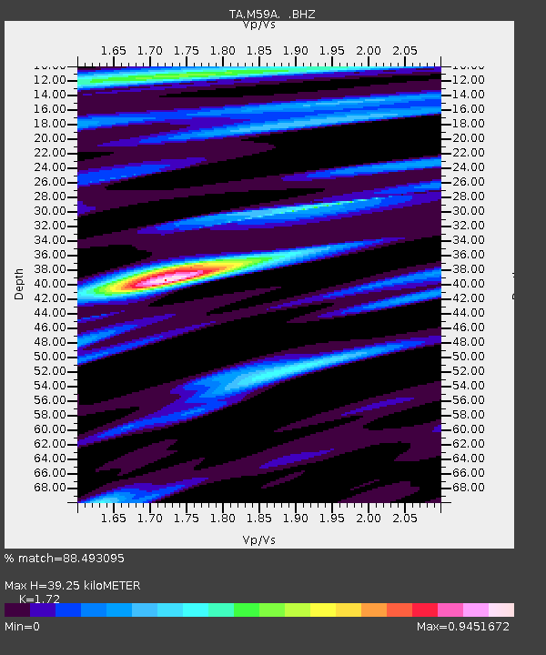
| Estimated Moho Depth: |
39.25 km |
| Estimated Crust Vp/Vs: |
1.72 |
| Assumed Crust Vp: |
6.283 km/s |
| Estimated Crust Vs: |
3.653 km/s |
| Estimated Crust Poisson's Ratio: |
0.24 |
|
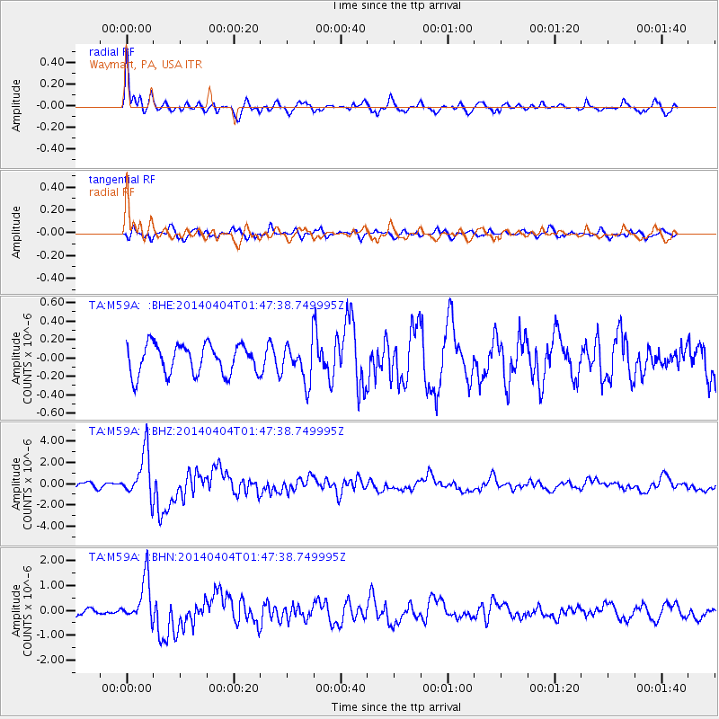
| Radial Match: |
88.493095 % |
| Radial Bump: |
400 |
| Transverse Match: |
78.8104 % |
| Transverse Bump: |
400 |
| SOD ConfigId: |
626651 |
| Insert Time: |
2014-04-22 09:58:52.381 +0000 |
| GWidth: |
2.5 |
| Max Bumps: |
400 |
| Tol: |
0.001 |
|
Signal To Noise
| Channel | StoN | STA | LTA |
| TA:M59A: :BHZ:20140404T01:47:38.749995Z | 7.3896866 | 2.1985447E-6 | 2.975153E-7 |
| TA:M59A: :BHN:20140404T01:47:38.749995Z | 6.806741 | 8.84409E-7 | 1.2993134E-7 |
| TA:M59A: :BHE:20140404T01:47:38.749995Z | 1.3054059 | 2.096723E-7 | 1.6061847E-7 |
| Arrivals |
| Ps | 4.7 SECOND |
| PpPs | 16 SECOND |
| PsPs/PpSs | 21 SECOND |


