You are here: Home > Network List > TA - USArray Transportable Network (new EarthScope stations) Stations List
> Station N48A Decatur, IN, USA > Earthquake Result Viewer
N48A Decatur, IN, USA - Earthquake Result Viewer
| Earthquake location: |
Near Coast Of Northern Chile |
| Earthquake latitude/longitude: |
-20.6/-70.7 |
| Earthquake time(UTC): |
2014/04/04 (094) 01:37:51 GMT |
| Earthquake Depth: |
20 km |
| Earthquake Magnitude: |
6.1 MWP, 6.1 MWB, 6.1 MWW, 6.3 MWC |
| Earthquake Catalog/Contributor: |
NEIC PDE/NEIC COMCAT |
|
| Network: |
TA USArray Transportable Network (new EarthScope stations) |
| Station: |
N48A Decatur, IN, USA |
| Lat/Lon: |
40.86 N/85.03 W |
| Elevation: |
250 m |
|
| Distance: |
62.6 deg |
| Az: |
347.827 deg |
| Baz: |
164.906 deg |
| Ray Param: |
0.06010344 |
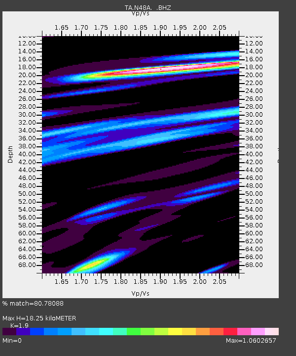
| Estimated Moho Depth: |
18.25 km |
| Estimated Crust Vp/Vs: |
1.90 |
| Assumed Crust Vp: |
6.498 km/s |
| Estimated Crust Vs: |
3.42 km/s |
| Estimated Crust Poisson's Ratio: |
0.31 |
|
| Radial Match: |
80.78088 % |
| Radial Bump: |
384 |
| Transverse Match: |
60.730244 % |
| Transverse Bump: |
400 |
| SOD ConfigId: |
626651 |
| Insert Time: |
2014-04-22 09:59:23.358 +0000 |
| GWidth: |
2.5 |
| Max Bumps: |
400 |
| Tol: |
0.001 |
|

Signal To Noise
| Channel | StoN | STA | LTA |
| TA:N48A: :BHZ:20140404T01:47:42.700007Z | 11.312683 | 1.6199614E-6 | 1.4319869E-7 |
| TA:N48A: :BHN:20140404T01:47:42.700007Z | 6.2532125 | 8.8234447E-7 | 1.4110259E-7 |
| TA:N48A: :BHE:20140404T01:47:42.700007Z | 2.039997 | 2.868448E-7 | 1.406104E-7 |
| Arrivals |
| Ps | 2.6 SECOND |
| PpPs | 7.8 SECOND |
| PsPs/PpSs | 10 SECOND |


